

where do the big boys bed (topo) ?

-
dreaming bucks
- Status: Offline
where do the big boys bed (topo) ?
Looking for some tips to where the big boys would bed on our land... We own 60 acres which I outlines in black lines... It's all woods, and we have an easement, which I also marked with the black marker... It's all crops on both the North and South side of us, with a little run off damn on the far north line... I wish I was better with marking maps on a computer, but I'm just not that computer friendly, but I'm learning... I will try to get just a regular picture of uploaded too... I believe the elevations are in 5ft grads, cant figure out how to change that either...
-
dreaming bucks
- Status: Offline
-
dreaming bucks
- Status: Offline
-
dan
- Site Owner
- Posts: 41642
- Joined: Sat Feb 13, 2010 6:11 am
- Facebook: https://www.facebook.com/HuntingBeast/?ref=bookmarks
- Location: S.E. Wisconsin
- Contact:
- Status: Offline
Re: where do the big boys bed (topo) ?
I could not read the elevations on your map so I guessed a little...
I marked red spots I would look for or suspect buck beds
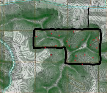
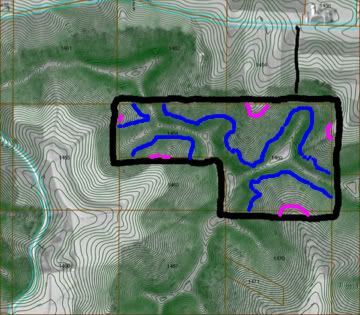
The top map might just look peppered with dots but there was reasons for there positions. Take a look at this map, the blue and pink lines dictate where I think you should walk looking for buck beds. They will either be up high on the points ( pink ) or along the edge of the steep areas (blue )
I marked red spots I would look for or suspect buck beds
The top map might just look peppered with dots but there was reasons for there positions. Take a look at this map, the blue and pink lines dictate where I think you should walk looking for buck beds. They will either be up high on the points ( pink ) or along the edge of the steep areas (blue )
-
Arrowbender

- 500 Club
- Posts: 1614
- Joined: Sun Feb 21, 2010 4:39 am
- Location: Minnie!
- Status: Offline
Re: where do the big boys bed (topo) ?
I can tell you where the does will be bedding.
Just south of Dan's pink line on your north line.
That whole top, south of that field should be loaded with does.
That would be a sanctuary in my woods. Go chase the bucks around early,but stay out of; and down wind of that area and you will be able to hunt that 60 very hard early and still have action during the rut.
IMO
-
dreaming bucks
- Status: Offline
Re: where do the big boys bed (topo) ?
dan wrote:I could not read the elevations on your map so I guessed a little...
I marked red spots I would look for or suspect buck beds
The top map might just look peppered with dots but there was reasons for there positions. Take a look at this map, the blue and pink lines dictate where I think you should walk looking for buck beds. They will either be up high on the points ( pink ) or along the edge of the steep areas (blue )
I know the map I gave you sucks and I'm working on a better one, but the areas you marked pink, are actually down at the bottome of the hills on each one.... If you look at all of your blue lines, we have a ridge that runs between all of them, otherwise the land runs down hill on all sides from all of your blue lines... right where you marked the little north pink line is actually a little water hole from run-off on that whole north side bowl...
-
dreaming bucks
- Status: Offline
Re: where do the big boys bed (topo) ?
Arrowbender wrote:I can tell you where the does will be bedding.
Just south of Dan's pink line on your north line.
That whole top, south of that field should be loaded with does.
That would be a sanctuary in my woods. Go chase the bucks around early,but stay out of; and down wind of that area and you will be able to hunt that 60 very hard early and still have action during the rut.
IMO
Arrowbender...
I agree with you on the doe bedding area.... I don't know if the map shows it correctly, but that whole area you are talking about is really not a flat, it steadily goes up hill, it's kind've a big bowl area that all steadily goes up hill until it gets to Dan's blue line and then is really steep and then it's the ridge, which is probably 50 yards wide at the most towards the south, and then it starts going down hill towards the south again....
Does anybody know how to download a map on here ? I got the one I got off of sauk county gis mapping website, and it works, but I hate the graduations on the topo.....
-
- Advertisement
Who is online
Users browsing this forum: No registered users and 36 guests