


new to topo scouting
-
james498
- Posts: 11
- Joined: Mon Aug 18, 2014 5:47 pm
- Status: Offline
new to topo scouting
looking for a little help...im used to hunting a small piece of property in upstate ny this year im taking a trip to pa for a four day hunt. no time to scout and i have never used topos for scouting before. any pointers would be much appreciated thanks a lot
-
VT Outfitter
- Posts: 65
- Joined: Sat Aug 16, 2014 1:43 am
- Location: Vermont
- Contact:
- Status: Offline
Re: new to topo scouting
I use topos for new areas, usually coupled with in the field scouting. It is difficult to say exactly where the key stand site locations are with out knowing what kid of woods it is made of, where the thick stuff is, natural food sources, water ways, where your access to the property is. I find the deer will follow the path of least resistance for travel. They will follow edges of steep terrain, edges of thick stuff, edges of meadows, edges of ponds, and any terrain features that would steer them in a direction. Can you offer anymore info on your property?
Whitetail Strategies Guide Service
www.whitetailstrategies.net
www.whitetailstrategies.net
-
VT Outfitter
- Posts: 65
- Joined: Sat Aug 16, 2014 1:43 am
- Location: Vermont
- Contact:
- Status: Offline
Re: new to topo scouting
I cant figure out how to attach the new file of your map with the marked spots where I would say to look.
Whitetail Strategies Guide Service
www.whitetailstrategies.net
www.whitetailstrategies.net
-
james498
- Posts: 11
- Joined: Mon Aug 18, 2014 5:47 pm
- Status: Offline
Re: new to topo scouting

[ Post made via iPhone ]

-
james498
- Posts: 11
- Joined: Mon Aug 18, 2014 5:47 pm
- Status: Offline
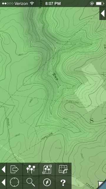
Re: new to topo scouting
It's almost all heavy forest area...it's a small section of a state park. It's relatively all flat. I narrowed it down to this section Looks like the only real changes in elevation in the surrounding area. Can access it from all sides there's road and pipe line cut outs on all sides where I get in from any angle. Stream runs down the center of that gully My brother hunts there every year. Not sure in this exact location and always sees real nice bucks but never really puts the leg work in. He's more of the park the car and go in a hundred yards kind of guy. So I know there good deer there Thanks for the feed back. Looking to make this trip worth it Scouting is half the fun. Learning a lot from the site already
[ Post made via iPhone ]
[ Post made via iPhone ]
-
- Advertisement
Who is online
Users browsing this forum: No registered users and 14 guests