New Area

Post topo’s and Aerial photos for free advice. Food plotting, land manipulation, water holes, ect.
  • Advertisement

HB Store


John.270
Posts: 34
Joined: Thu Aug 21, 2014 2:50 am
Status: Offline

New Area

Unread postby John.270 » Thu Aug 21, 2014 1:32 pm

Hello all. Thanks for taking the time to look at this. This is a large lake with about 33K acres of public land. I am focusing on a small portion of that public land. I was able to secure access to a 200 acre farm (looks like soybeans) that is in front of the public lands and a small 26 acre parcel in front of the farm. So you have Lake->Public->Farm->Small Parcel.

Here is an overview:

Image

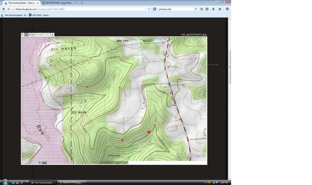
So the areas in the green lines are public. The farm has one huge field and one small one near the road. The red box is the 26 acres parcel. There is a river in that area. The white line through the public area is a hiking trail.

Here is the topo:

Image

Here are some additional photos closer and farther (for context)

Image

Image

Image

So I am trying to figure out where the deer might be bedding and where to set a stand (using only a climber this year). I am a little behind the 8-ball in scouting as I received permission recently. I have watched many deer cross the highway to access the large open field on the farm. I do not have permission for that area. Possible entrance methods are the hiking trail, a forest road from near the boat launch, and the road in front of the farm/parcel. This is for archery.

Thanks for looking. After this season and walking the area I should know a lot more to correlate with the photos and topo.


62kodiak
500 Club
Posts: 779
Joined: Tue Nov 26, 2013 3:15 pm
Location: North Metro, MN
Status: Offline

Re: New Area

Unread postby 62kodiak » Fri Aug 22, 2014 4:25 am

Here's a bump to the top. Welcome to the Beast.
It's not the knowing that's difficult, but the doing.
John.270
Posts: 34
Joined: Thu Aug 21, 2014 2:50 am
Status: Offline

Re: New Area

Unread postby John.270 » Fri Aug 22, 2014 9:29 am

Thanks 62kodiak

Here is a photo with a little more information. The red lines represent multiple deer I have seen crossing the road into the field. The red stars are deer sightings. The blue symbol is in the general area of a ton of sign on a trail including tracks and scat. The scat tasted like they were feeding near....just kidding not that into it! The hill near the lake was covered with acorns and nuts. To the SE of the blue symbol is a large flat area I think may be some doe bedding.

Image
dan
Site Owner
Posts: 41642
Joined: Sat Feb 13, 2010 6:11 am
Facebook: https://www.facebook.com/HuntingBeast/?ref=bookmarks
Location: S.E. Wisconsin
Contact:
Status: Offline

Re: New Area

Unread postby dan » Fri Aug 22, 2014 9:45 am

Image
John.270
Posts: 34
Joined: Thu Aug 21, 2014 2:50 am
Status: Offline

Re: New Area

Unread postby John.270 » Fri Aug 22, 2014 10:52 am

dan wrote:Image


Thanks Dan! Just to be clear are the red dots potential bedding areas or treestand locations?
dan
Site Owner
Posts: 41642
Joined: Sat Feb 13, 2010 6:11 am
Facebook: https://www.facebook.com/HuntingBeast/?ref=bookmarks
Location: S.E. Wisconsin
Contact:
Status: Offline

Re: New Area

Unread postby dan » Fri Aug 22, 2014 11:19 am

Thanks Dan! Just to be clear are the red dots potential bedding areas or treestand locations?
Bedding
John.270
Posts: 34
Joined: Thu Aug 21, 2014 2:50 am
Status: Offline

Re: New Area

Unread postby John.270 » Fri Aug 22, 2014 11:33 am

Thanks Dan. I figured that was the case. I'll let you know how it turns out.
dan
Site Owner
Posts: 41642
Joined: Sat Feb 13, 2010 6:11 am
Facebook: https://www.facebook.com/HuntingBeast/?ref=bookmarks
Location: S.E. Wisconsin
Contact:
Status: Offline

Re: New Area

Unread postby dan » Fri Aug 22, 2014 10:01 pm

The points along the water look classic, but with the human trail, oil rigs, and all the activity, I figured these lesser points near the crops would pay off much better.


  • Advertisement

Return to “Land Management”

Who is online

Users browsing this forum: No registered users and 31 guests