


New Property Topo Help
-
seazofcheeze

- 500 Club
- Posts: 3863
- Joined: Wed Sep 18, 2013 1:13 pm
- Location: Billings, MT
- Status: Offline
New Property Topo Help
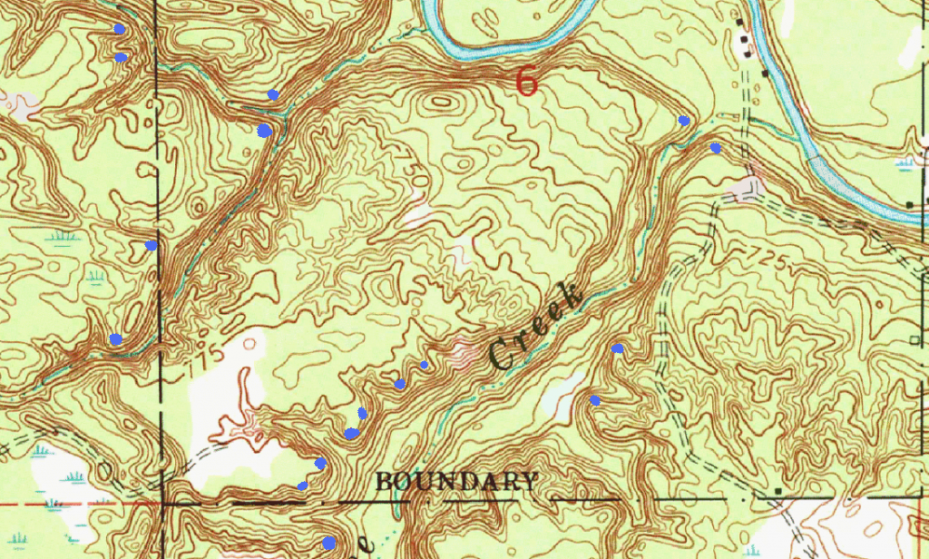
The dashed line running north and south on the right 1/3 of the picture is an atv trail/old logging road. The rest of the parcel is a mix of pine and hardwoods. Just to the west of where it says "creek" is a good clump of 20-30 oaks. The nearest ag fields are 3/4-1 mile away. The creeks are about 4-8ft wide and 1-2 ft deep so easily crossing in most areas. The heavy blue line to the north is a river about 30yds wide and 2-4ft deep in most areas. I found 3 really good rubs on this property this spring. Hoping the buck in question survived last season. I'd appreciate any help. thanks!

-
dan
- Site Owner
- Posts: 41632
- Joined: Sat Feb 13, 2010 6:11 am
- Facebook: https://www.facebook.com/HuntingBeast/?ref=bookmarks
- Location: S.E. Wisconsin
- Contact:
- Status: Offline
Re: New Property Topo Help
I marked potential bedding with blue dots... I really like the series of bedding positions in a line on the ridge below the word creek and would expect there to be good bucks bedding there on west and north winds when those oaks are dropping.
-
seazofcheeze
- 500 Club
- Posts: 3863
- Joined: Wed Sep 18, 2013 1:13 pm
- Location: Billings, MT
- Status: Offline
Re: New Property Topo Help
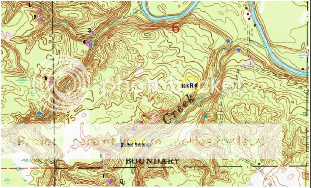
Dan, first of all, thank you for taking the time to look at this map. Second, I have (quite) a few follow up questions, as last year was my first year of total "beast" style hunting, so I still have a lot to learn. I've been reading the forum regularly, and I've watched both "Marsh Bucks" and "Hill Country Bucks" DVDs several times each. I've numbered a few of the spots for ease of discussion.
Spots 1-7. I understand from watching hill country DVDs, at least on a basic level, why you chose these spots. Can you elaborate on why you chose spots 3&4 and to some degree 5? I'm trying to understand the process. I wouldn't have picked up on these spots because the points dont look "pointy" enough to me. Why do you think 3,4, and 5 have buck bedding potential?
The blue w/green dot to the south of location #5, based on the little I know, I might try putting a stand directly south across the creek along the top 1/3 elevation line (small green dot is potential stand site). I also know there is an AG field 1/4-1/2 mile directly south, so I think that would be the main food source for a buck bedding in the location. I'm assuming the buck is bedding there on a north wind, so he is bedded wind to his back and looking down the point. He gets up and heads south to AG field, the destination food source. Where would you put a stand in this situation, and more importantly, WHY would you put in there?
Does the cedar swamp I've outlined have any impact on the bedding locations immediately north of it? The bedding locations you identified northwest of the cedar swamp had the BEST (and sadly only) mature buck sign I've seen on any property in my area.
The rest of the locations, I tried to color coordinate the beds you identified with places I think might be potential stand sites (small color dots are stand sites for bedding areas you identified of the same color). Can you comment on my logic in placing these potential stands sites, and, if I went wrong, why?
I understand this is a ridiculously long list of questions, but I would be happy if you could comment on any or all of them.
Thanks!

-
dan
- Site Owner
- Posts: 41632
- Joined: Sat Feb 13, 2010 6:11 am
- Facebook: https://www.facebook.com/HuntingBeast/?ref=bookmarks
- Location: S.E. Wisconsin
- Contact:
- Status: Offline
Re: New Property Topo Help
Spots 1-7. I understand from watching hill country DVDs, at least on a basic level, why you chose these spots. Can you elaborate on why you chose spots 3&4 and to some degree 5? I'm trying to understand the process. I wouldn't have picked up on these spots because the points dont look "pointy" enough to me. Why do you think 3,4, and 5 have buck bedding potential?
The bends in terrain make points just like the other spots... The only issue I see with these picks is they are more likely to have human traffic than the normal points that people tend to walk past. Kind of the same as "end points"... But, they are certainly worth checking. Bucks like bedding above creeks for both the escape factor and something to drink.
The blue w/green dot to the south of location #5, based on the little I know, I might try putting a stand directly south across the creek along the top 1/3 elevation line (small green dot is potential stand site). I also know there is an AG field 1/4-1/2 mile directly south, so I think that would be the main food source for a buck bedding in the location. I'm assuming the buck is bedding there on a north wind, so he is bedded wind to his back and looking down the point. He gets up and heads south to AG field, the destination food source. Where would you put a stand in this situation, and more importantly, WHY would you put in there?
Thats a question I get asked a lot... I personally would not bank on him heading for the ag field... There are lots of preferred foods that are less noticed within woods and swamps... He might be, but he also might not. Scouting the area now would be the best bet. The spot you marked looks good if he is heading south, I would get a little closer if its possible... I don't know for sure without looking from the potential bedding area to see what the buck can see... I also like the top of the draw to the west
Does the cedar swamp I've outlined have any impact on the bedding locations immediately north of it? The bedding locations you identified northwest of the cedar swamp had the BEST (and sadly only) mature buck sign I've seen on any property in my area.
It might... I would bet there are a lot of doe bedding in the cedars. Maybe even some bucks. But, I think the main reason your seeing the best sign in that area is because the best bedding in the area is right there, and you have the oaks nearby... I thought I mentioned that in the 1st post, but anywho, the beds along that ridge are set up for the predominant winds of North and West and if they have a different wind they can just drop down and bed in the cedars... I would expect the best bucks in the area to be calling that ridge home.
The rest of the locations, I tried to color coordinate the beds you identified with places I think might be potential stand sites (small color dots are stand sites for bedding areas you identified of the same color). Can you comment on my logic in placing these potential stands sites, and, if I went wrong, why?
For the most part they look good... Are you planning morning sits right over the beds? I noticed some of your dots on top of mine... If so I would change some of those locations.
-
seazofcheeze
- 500 Club
- Posts: 3863
- Joined: Wed Sep 18, 2013 1:13 pm
- Location: Billings, MT
- Status: Offline
Re: New Property Topo Help
dan wrote:The bends in terrain make points just like the other spots... The only issue I see with these picks is they are more likely to have human traffic than the normal points that people tend to walk past. Kind of the same as "end points"... But, they are certainly worth checking. Bucks like bedding above creeks for both the escape factor and something to drink.
I think I understand this now. I mistakenly believed that only "pointy" points would be likely bedding areas.
dan wrote:Thats a question I get asked a lot... I personally would not bank on him heading for the ag field... There are lots of preferred foods that are less noticed within woods and swamps... He might be, but he also might not. Scouting the area now would be the best bet. The spot you marked looks good if he is heading south, I would get a little closer if its possible... I don't know for sure without looking from the potential bedding area to see what the buck can see... I also like the top of the draw to the west
Some more scouting in this area is definitely in order. I believe I saw the buck in question two times last year while glassing, both times in the AG field. However, I spent a lot of time glassing that field, and he was not a regular visitor...at least not during daylight. So, it's very likely, as you mentioned, that he is utilizing other food sources...again, more scouting is in order to nail down where those food sources are at. I will also check out the draw as you recommended.
dan wrote:It might... I would bet there are a lot of doe bedding in the cedars. Maybe even some bucks. But, I think the main reason your seeing the best sign in that area is because the best bedding in the area is right there, and you have the oaks nearby... I thought I mentioned that in the 1st post, but anywho, the beds along that ridge are set up for the predominant winds of North and West and if they have a different wind they can just drop down and bed in the cedars... I would expect the best bucks in the area to be calling that ridge home.
Dan, you did mention that is the area of best bedding in your first post. The only reason I mentioned the cedar swamp is because I don't have as much experience hunting in or around them, and I was just curious of your opinion on how that might affect the deer movement in that area given it is adjacent to the prime bedding locations.
dan wrote:For the most part they look good... Are you planning morning sits right over the beds? I noticed some of your dots on top of mine... If so I would change some of those locations.
I will only be hunting near the locations marked with the small dots. I tried to color coordinate the single dots with the bedding locations you identified. The idea was to take a bedding area you identified, I add a color ex. red, then the red single dot(s) is potential stand locations based on the bedding area you identified with the matching color (if that makes any sense...harder to explain than I thought). Basically, small red dot is a stand location for the corresponding bedding area you identified with the red dot. Long story short, probably very few if any morning hunts on this property, and, if so, my plan would not be sitting right over the beds...probably 40-75 yards down wind to catch them entering the bed on the "J-hook".
Again, thanks a lot for your comments. The amount of time you put into this website is absolutely awesome in my opinion. It's really a world-class hunting resource.
-
- Advertisement
Who is online
Users browsing this forum: No registered users and 10 guests