


Public Swamp Disection
-
RaisedByWolves

- 500 Club
- Posts: 2441
- Joined: Tue May 18, 2010 12:49 pm
- Location: WI
- Status: Offline
Public Swamp Disection
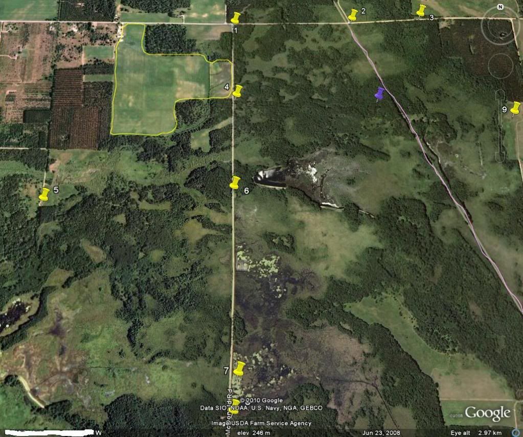
Hoping to get some advice on scouting this public property for buck beds. This section as you can see consists of swamp thickets, ponds, brush, popple and some crop fields to the northwest. i've talked to people who have seen/shot very mature deer in or close to this area so i know it holds big deer. This area is just one part of a property that consists of thousands of acres. More people hunt on the higher ground over a mile west of here. One benefit is that there is access on many sides. All of my numbered yellow thumbtacks indicate public access. I have marked a crop field(yellow) and a railroad track i can also use to access(pink). The blue thumbtack is where i found many large scrapes on a subtle ridge during a quick scout last year. Basically everything in the picture is public except the crop fields. I was thinking about starting at spots #4,5,and 6 because they are close to the fields. There are also more fields to the NW of my marked field. Any suggestions on which points might hold bedding would be greatly appreciated!
When better is possible, good is never good enough
-
dan
- Site Owner
- Posts: 41642
- Joined: Sat Feb 13, 2010 6:11 am
- Facebook: https://www.facebook.com/HuntingBeast/?ref=bookmarks
- Location: S.E. Wisconsin
- Contact:
- Status: Offline
Re: Public Swamp Disection
Easy property for map scouting... However, it is lacking in detail. If it were zoomed a little closer I think I would be able to make out the deer trails in the marshes which would really help... Also, if a person posts both a topo and an aerial it is much easier for me to decipher exactly what Im looking at... But, since this is what you posted, this is what Im going by...
Photo-bucket shrinks the pic's sorry.
The red dots are where I would strongly suspect mature buck beds. The green dots represent where I would likely end up with my ambush spots, however, exact positioning would be based on exact position of the beds, relation to the wind, and how close I feel I can get without bumping the buck.
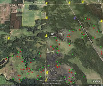
-
Hodag Hunter

- 500 Club
- Posts: 3837
- Joined: Sat Feb 27, 2010 5:14 pm
- Location: Northern WI
- Status: Offline
Re: Public Swamp Disection
I can post a topo if you'd like? 
-
RaisedByWolves
- 500 Club
- Posts: 2441
- Joined: Tue May 18, 2010 12:49 pm
- Location: WI
- Status: Offline
Re: Public Swamp Disection
Thanks for the quick replies guys. When i zoom in on the spot closer i can barely make out deer trails but they are there. Hodag, feel free to post some topo if you like but that is really ok. i plan on getting in there and snooping around anyway. Dan, i like your choices for suspected buck beds, i understand the isolated patches of brush, but am still learning the islands and major edges. you seem to have chosen the major edges and points, and not so much the inner ones. i would have spent alot of time just west of lot 6 investigating those pockets of swamp in the woods, and not so much to the SW near the major point in the marsh. Thanks for showing me a different point of veiw, that helps alot and makes more sense 
When better is possible, good is never good enough
-
RaisedByWolves
- 500 Club
- Posts: 2441
- Joined: Tue May 18, 2010 12:49 pm
- Location: WI
- Status: Offline
Re: Public Swamp Disection
p.s. if you thought that was an easy map to mark, i got plenty more where that came from!
When better is possible, good is never good enough
-
Hodag Hunter
- 500 Club
- Posts: 3837
- Joined: Sat Feb 27, 2010 5:14 pm
- Location: Northern WI
- Status: Offline
Re: Public Swamp Disection
On your map you can walk quite easy from 6 to 5 and continue on to K. Just be careful west of 6 as slightly north is a portion of private.
I have hunted this area on and off for 15 years, and know it better than most. Know the landowners with the field real well and they along with others own more than what you have outlined in yellow. Just check a plot book and you should be ok.
Some areas have good potential but can and does get hit hard with hunters. Alot of duck hunters, and small game, but bowhunting during midweek can be good.
My advice would be to pick smaller areas with in the map and concentrate on those areas and learn every square inch. There is nice bucks in this area but can do some pretty unusual things. (Like big bucks are normal )
I have hunted this area on and off for 15 years, and know it better than most. Know the landowners with the field real well and they along with others own more than what you have outlined in yellow. Just check a plot book and you should be ok.
Some areas have good potential but can and does get hit hard with hunters. Alot of duck hunters, and small game, but bowhunting during midweek can be good.
My advice would be to pick smaller areas with in the map and concentrate on those areas and learn every square inch. There is nice bucks in this area but can do some pretty unusual things. (Like big bucks are normal
-
RaisedByWolves
- 500 Club
- Posts: 2441
- Joined: Tue May 18, 2010 12:49 pm
- Location: WI
- Status: Offline
Re: Public Swamp Disection
thanks for the tip Hodag! I am aware of all the private/public boundaries, I just wanted to make it easy for you guys to give opinions I have a friend with 80 acres on the southern side off of ashley road, some of his game cam pics are very impressive! I look forward to getting to know the area, lots of nasty stuff and big buck potential
When better is possible, good is never good enough
-
Hodag Hunter
- 500 Club
- Posts: 3837
- Joined: Sat Feb 27, 2010 5:14 pm
- Location: Northern WI
- Status: Offline
Re: Public Swamp Disection
Do you live in this area?....I know a few guys with land in that area.
-
RaisedByWolves
- 500 Club
- Posts: 2441
- Joined: Tue May 18, 2010 12:49 pm
- Location: WI
- Status: Offline
Re: Public Swamp Disection
No, I live in Appleton..pretty cool I see your in Greenville. My friend who hunts there does not own the land but a family friend of theirs from wisconsin rapids(i believe) does. I am not sure of their name, but the family who hunts it are the Bauers..Up until this year they had permission to bow and gun hunt, but this year they can only bowhunt, the owner has grandchildren getting to the age where he wants to start getting them into hunting
When better is possible, good is never good enough
-
- Advertisement
Who is online
Users browsing this forum: No registered users and 45 guests