


Last one
-
PLB

- 500 Club
- Posts: 6974
- Joined: Sat Feb 20, 2010 3:49 pm
- Location: NE Wisconsin
- Status: Offline
-
blackwolf
- 500 Club
- Posts: 839
- Joined: Wed Mar 10, 2010 4:15 pm
- Location: Eau Claire, WI
- Status: Offline
Re: Last one
Another nice piece. I like the looks of the larger highland just above the creek in central bottom of pic.
-
magicman54494

- 500 Club
- Posts: 4188
- Joined: Fri Feb 26, 2010 6:05 pm
- Location: central and northern WI
- Status: Offline
Re: Last one
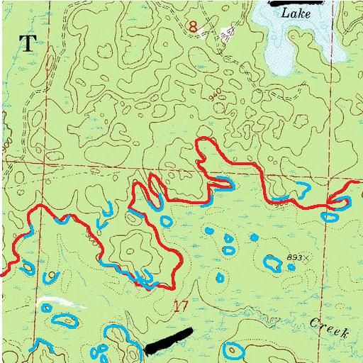
to get started I'd walk the red line and look for sign. I'd check closer in areas where sign is present. The blue lines are where I'd expect to find sign. There are soooo many places for a buck to hang out that it's hard to look at a topo and pick out spots. I like sharp contour breaks on the SE sides, add some blowdowns or heavy cover and you have gold. Islands in the swamps or points are great places too. A single cedar tree in a low swampy area could hold a good bed.
Misty River Trackers base camp : https://www.facebook.com/groups/307702256717984/
Misty River Trackers You tube: https://www.youtube.com/channel/UCl5aA6 ... qd_bJAJl0A
Misty River Trackers You tube: https://www.youtube.com/channel/UCl5aA6 ... qd_bJAJl0A
-
magicman54494
- 500 Club
- Posts: 4188
- Joined: Fri Feb 26, 2010 6:05 pm
- Location: central and northern WI
- Status: Offline
Re: Last one
....... and try the red squares for gills and crappies.
Misty River Trackers base camp : https://www.facebook.com/groups/307702256717984/
Misty River Trackers You tube: https://www.youtube.com/channel/UCl5aA6 ... qd_bJAJl0A
Misty River Trackers You tube: https://www.youtube.com/channel/UCl5aA6 ... qd_bJAJl0A
-
dan
- Site Owner
- Posts: 41635
- Joined: Sat Feb 13, 2010 6:11 am
- Facebook: https://www.facebook.com/HuntingBeast/?ref=bookmarks
- Location: S.E. Wisconsin
- Contact:
- Status: Offline
Re: Last one
Magics map and description is pretty much the same way I would do it.
-
- Advertisement
Who is online
Users browsing this forum: No registered users and 11 guests