


Why do my topos stink?
-
kwaldeier

- 500 Club
- Posts: 968
- Joined: Fri Jul 23, 2010 10:30 am
- Status: Offline
Why do my topos stink?
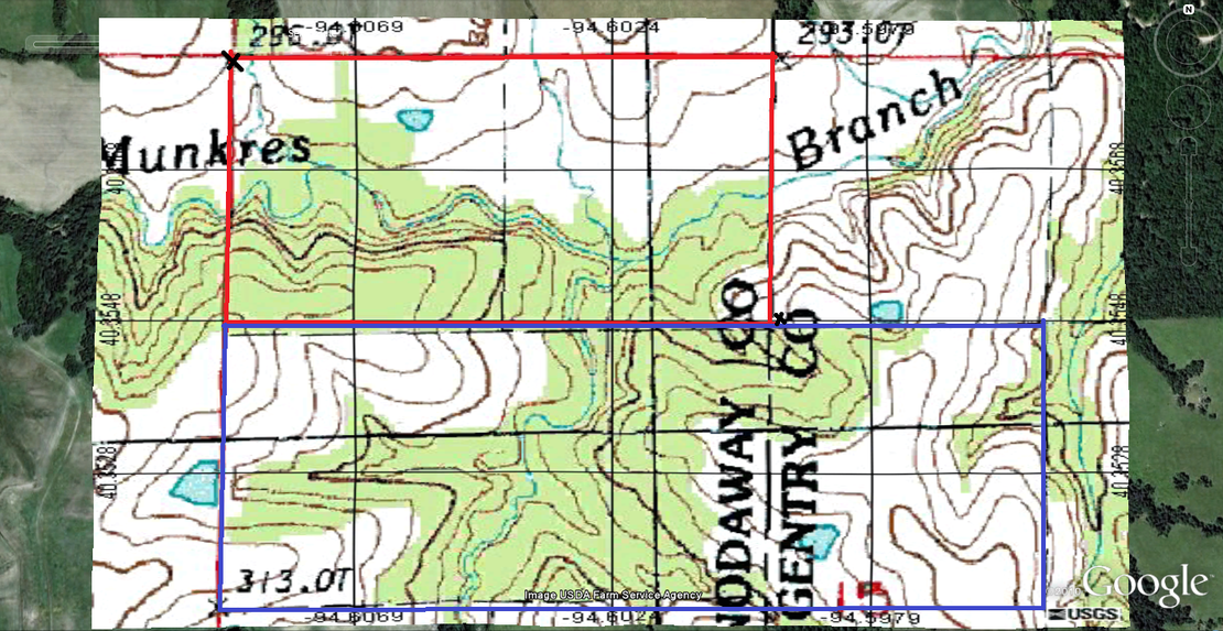
Is it just me or do my topo maps stink? Even when i am closest it is still like a mile away and it seems like the lines are 50 ft apart. It just seems like they do me little to no good at all. I see all these other amazing topo maps where they are within 50 ft and the lines are 2 ft apart. Where on gods earth are you getting them so amazingly detailed!!!?!??!?! Even mine from mytopo.com are that way. See-
-
DEERSLAYER

- Super Moderator
- Posts: 8353
- Joined: Sun Mar 14, 2010 3:22 pm
- Location: Western L.P. of MI
- Contact:
- Status: Offline
Re: Why do my topos stink?
The lines are elevation changes. Assuming the intervals are the same, the closer the lines the steeper the terrain and the farther the lines the flatter the terrain. Your lines are at 3' foot intervals so every three feet change in elevation there will be a line and the more gradual the slope the further apart the lines will be. What all this tells me is your place has gradual sloping hills that are not very high. If the same lines intervals were 10' intervals it would be over three times steeper.
You cannot invade mainland America. There would be a rifle behind every blade of grass.
Isoroku Yamamoto, Japanese Admiral
Isoroku Yamamoto, Japanese Admiral
-
kwaldeier
- 500 Club
- Posts: 968
- Joined: Fri Jul 23, 2010 10:30 am
- Status: Offline
Re: Why do my topos stink?
There are alot of gradual slopes(Which stink for trying to find beds!)but Mine just doesn't seem as detailed as some...seems like people have 1ft intervals  lol
lol
-
DEERSLAYER
- Super Moderator
- Posts: 8353
- Joined: Sun Mar 14, 2010 3:22 pm
- Location: Western L.P. of MI
- Contact:
- Status: Offline
Re: Why do my topos stink?
The other topo's you refer to are either steeper and/or taller. Often 100's of feet tall. You have a good property with some nice bucks on it. It's just going to take some boot leather, time and your thinking cap. 
You cannot invade mainland America. There would be a rifle behind every blade of grass.
Isoroku Yamamoto, Japanese Admiral
Isoroku Yamamoto, Japanese Admiral
-
Mountain Man

- 500 Club
- Posts: 966
- Joined: Wed Feb 17, 2010 4:25 pm
- Location: SE Wisconsin
- Status: Offline
Re: Why do my topos stink?
DEERSLAYER wrote:The lines are elevation changes. Assuming the intervals are the same, the closer the lines the steeper the terrain and the farther the lines the flatter the terrain. Your lines are at 3' foot intervals so every three feet change in elevation there will be a line and the more gradual the slope the further apart the lines will be. What all this tells me is your place has gradual sloping hills that are not very high. If the same lines intervals were 10' intervals it would be over three times steeper.
DEERSLAYER - How do you come up with 3' intervals on that map? I have done a lot of topo map work in college and for my job and I don't recall ever seeing a USGS topo map with 3' contour intervals (I'm not saying it isn't possible as a map could be made with whatever interval the map maker wants but I just haven't seen 3' on a USGS topo). Usually they are 2' intervals if the topography is subtle, 10' or 20' is the terrain is steeper, and 100' if really steep.
kwaldeier - you need to use USGS 7.5-minute quadrangles to get the most detail in the topography but even then if it is steep you still might only get an interval of 20 or 100 feet on those. Then once you narrow down some likely bedding spots you will need to get out there and have a closer look to fill in those blanks. Many counties (at least in Wisconsin) have really nice GIS websites where you can add the topo lines over an aerial photo and zoom in and out to whatever scale you like. I'm not sure what other states or counties outside WI have but you should look into that.
-
DEERSLAYER
- Super Moderator
- Posts: 8353
- Joined: Sun Mar 14, 2010 3:22 pm
- Location: Western L.P. of MI
- Contact:
- Status: Offline
Re: Why do my topos stink?
Mountain Man wrote:DEERSLAYER - How do you come up with 3' intervals on that map? I have done a lot of topo map work in college and for my job and I don't recall ever seeing a USGS topo map with 3' contour intervals (I'm not saying it isn't possible as a map could be made with whatever interval the map maker wants but I just haven't seen 3' on a USGS topo). Usually they are 2' intervals if the topography is subtle, 10' or 20' is the terrain is steeper, and 100' if really steep...
Correction! It's not 3' intervals it's 4'. Probably just as unusual though. I usually see 10' intervals the most with 20' quite common and 5' here and there. That about covers it in most instances from what I have seen.
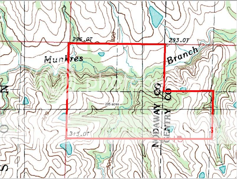
You can't see this on the map he posted here. Here is a larger view.
You cannot invade mainland America. There would be a rifle behind every blade of grass.
Isoroku Yamamoto, Japanese Admiral
Isoroku Yamamoto, Japanese Admiral
-
Mountain Man
- 500 Club
- Posts: 966
- Joined: Wed Feb 17, 2010 4:25 pm
- Location: SE Wisconsin
- Status: Offline
Re: Why do my topos stink?
That view helps. Thanks.
-
Autumn Ninja
- Status: Offline
Re: Why do my topos stink?
Your maps show awesome detail....the maps in my area are at 10' intervals, which would so alot less detail then your map does. I would mark it up but I've already marked this map in the past and I hate marking the same maps over and over. If I remember right....You can hunt land to the north also.
-
- Advertisement
Who is online
Users browsing this forum: No registered users and 10 guests