How Might Bucks Use this Bedding Area??

Discuss the science of figuring out our prey through good detective work.
  • Advertisement

HB Store


User avatar
SD_Bowhunter
Posts: 96
Joined: Sat Aug 31, 2013 12:43 am
Location: Minneapolis, MN
Status: Offline

How Might Bucks Use this Bedding Area??

Unread postby SD_Bowhunter » Sat Sep 09, 2017 2:13 am

The red lines are trails and the blue x's are where I found buck beds. Each of these beds had 3-4 rubs in them. Some had some decent height to them and you could tell that these beds have been used over many years from the healing on the trees. I have only been using the HB scouting methods for a year and am still a little green on how bucks use the wind to their advantage.

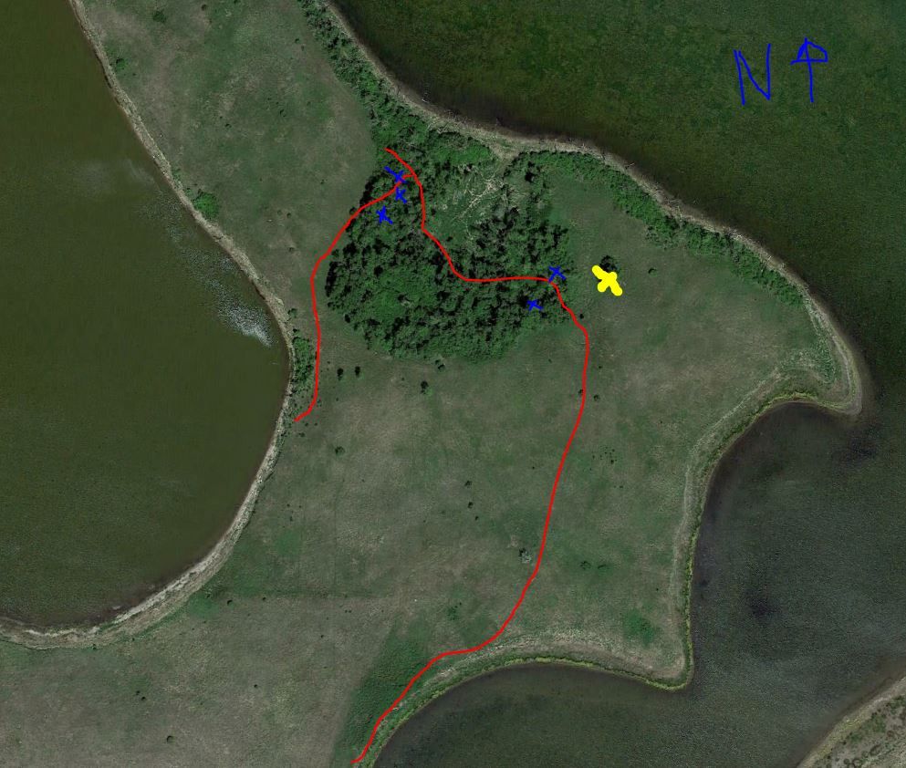
My big question is how would you seasoned beasts hunt this area. THere is a lone tree on the east side that I have marked in yellow that I think would be a good tree to start with. Predominant wind directs in the fall are NW, N and NE. The buck beds I found on the NW side were about 15 yards down the hill from the treeline. I am assuming they are bedding there on any sort of N, NW or SW wind and looking downhill into the bowl. There was a very heavy trail going down into the bowl that I marked in red. Do you think the bucks are coming into the beds from the east trail and working their way down through the bowl and then up into the bed instead of J hooking?

Image

Thanks for any input.


User avatar
brancher147
500 Club
Posts: 1414
Joined: Wed Aug 16, 2017 3:46 am
Location: West Virginia
Status: Offline

Re: How Might Bucks Use this Bedding Area??

Unread postby brancher147 » Sat Sep 09, 2017 9:56 am

Your tree looks like a good spot for an observation stand. Sit there with the right wind and see what happens. Will probably answer some of your questions. I don't know, I am not real familiar with mostly open farm country.
Some do. Some don't. I just might...
User avatar
Lockdown
Moderator
Posts: 9957
Joined: Fri Jul 18, 2014 4:16 pm
Location: MN
Status: Offline

Re: How Might Bucks Use this Bedding Area??

Unread postby Lockdown » Sat Sep 09, 2017 11:05 am

I'm pretty sure they're using the NW bed with a SE wind and east bed with a NW or westerly wind, especially if there is elevation change.

Were there a lot of beds in there? Possible issue of satellite deer or does? How wide is this tree grove?

My first thought was sneak in from the west/NW with a NW wind staying as far south as possible then set up on the south (more like SW) side of him. Hopefully he stages in the trees and you could get a shot. If he heads south you could get a shot at him quartering just before he gets your wind. That's if that trail is in range.

I think early season will be your best bet, probably from the ground :think:
User avatar
SD_Bowhunter
Posts: 96
Joined: Sat Aug 31, 2013 12:43 am
Location: Minneapolis, MN
Status: Offline

Re: How Might Bucks Use this Bedding Area??

Unread postby SD_Bowhunter » Fri Sep 15, 2017 1:59 am

Lockdown,
It appeared most of the beds in the NW corner were facing E/SE (downhill). So do you think they would be having the wind blowing into their face instead of over their back?

There were several beds in a pretty close area. However, I don't think I will be able to hunt anywhere but the edge of the trees since its so thick so I don't think satellite bedding will be an issue.

I think I am going to try from the ground in the spot you recommended and then if I see what I can observe on how they use the area.
User avatar
Lockdown
Moderator
Posts: 9957
Joined: Fri Jul 18, 2014 4:16 pm
Location: MN
Status: Offline

Re: How Might Bucks Use this Bedding Area??

Unread postby Lockdown » Fri Sep 15, 2017 6:00 am

SD_Bowhunter wrote:Lockdown,
It appeared most of the beds in the NW corner were facing E/SE (downhill). So do you think they would be having the wind blowing into their face instead of over their back?

There were several beds in a pretty close area. However, I don't think I will be able to hunt anywhere but the edge of the trees since its so thick so I don't think satellite bedding will be an issue.

I think I am going to try from the ground in the spot you recommended and then if I see what I can observe on how they use the area.


I think I misunderstood you at first. So the trees are the low ground? I was envisioning them being the high ground...

They will ALMOST always bed wind to back. So shape of the bed will tell you the story.

If the ground was flat I would about guarantee they'll be on the downwind edge of the trees looking across the open grass. Unless there is a bedding structure (rock, deadfall, etc) in the middle. If the trees were the high ground I would expect the same.

If trees are the low ground then it's not impossible they bed on the upwind side and look over the lower elevations. I see this out west.
User avatar
SD_Bowhunter
Posts: 96
Joined: Sat Aug 31, 2013 12:43 am
Location: Minneapolis, MN
Status: Offline

Re: How Might Bucks Use this Bedding Area??

Unread postby SD_Bowhunter » Sat Sep 16, 2017 1:34 am

Lockdown wrote:
SD_Bowhunter wrote:Lockdown,
It appeared most of the beds in the NW corner were facing E/SE (downhill). So do you think they would be having the wind blowing into their face instead of over their back?

There were several beds in a pretty close area. However, I don't think I will be able to hunt anywhere but the edge of the trees since its so thick so I don't think satellite bedding will be an issue.

I think I am going to try from the ground in the spot you recommended and then if I see what I can observe on how they use the area.


I think I misunderstood you at first. So the trees are the low ground? I was envisioning them being the high ground...

They will ALMOST always bed wind to back. So shape of the bed will tell you the story.

If the ground was flat I would about guarantee they'll be on the downwind edge of the trees looking across the open grass. Unless there is a bedding structure (rock, deadfall, etc) in the middle. If the trees were the high ground I would expect the same.

If trees are the low ground then it's not impossible they bed on the upwind side and look over the lower elevations. I see this out west.


Hopefully, this picture helps... the orange line represents the highest point. The blue circle represents the lowest point (bottom of the bowl). It's hard to see from the aerial, but as you approach this area from the south you are walking up a decent hill. Once your reach the top (the treeline) it immediately starts to slow down to the blue circle.
Image


  • Advertisement

Return to “Scouting”

Who is online

Users browsing this forum: No registered users and 18 guests