Aerial Photos

Discuss the science of figuring out our prey through good detective work.
  • Advertisement

HB Store


User avatar
Jonny
500 Club
Posts: 5762
Joined: Wed Oct 19, 2016 3:11 am
Location: In a van down by the river
Status: Offline

Aerial Photos

Unread postby Jonny » Sat Jan 28, 2017 9:01 am

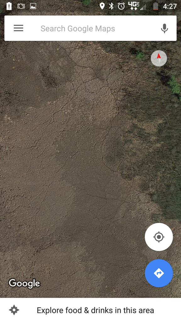
Not sure if anybody has mentioned this before, but if you zoom in on an aerial and see trails, can you assume deer use them? Something similar to this

Image

I am assuming these are deer trails because of where they are coming from and going to. Just wanted to hear input on it. Especially if you have hunted trails like this


You have a monkey Mr. Munson?
Rich M
500 Club
Posts: 3982
Joined: Thu Feb 18, 2016 1:29 pm
Location: Sunny Florida
Status: Offline

Re: Aerial Photos

Unread postby Rich M » Sat Jan 28, 2017 9:13 am

Have you gotten Dan's videos yet? You should.
User avatar
Mibowfreak
500 Club
Posts: 924
Joined: Fri Jan 30, 2015 12:21 pm
Status: Offline

Re: Aerial Photos

Unread postby Mibowfreak » Sat Jan 28, 2017 9:16 am

Yup you sure can. They usually stick out the best in some type of swamp or march.
User avatar
Mibowfreak
500 Club
Posts: 924
Joined: Fri Jan 30, 2015 12:21 pm
Status: Offline

Re: Aerial Photos

Unread postby Mibowfreak » Sat Jan 28, 2017 9:21 am

Also, I don't know if you know about changing the dates on the aerial images or not. But it is cool to be able to check those trails throughout the years on google earth. You can see if they have changed or if some have been the same for many years.
User avatar
Jonny
500 Club
Posts: 5762
Joined: Wed Oct 19, 2016 3:11 am
Location: In a van down by the river
Status: Offline

Re: Aerial Photos

Unread postby Jonny » Sat Jan 28, 2017 9:23 am

Rich M wrote:Have you gotten Dan's videos yet? You should.


I have the swamp and hill country videos. The swamps I noticed in his video were more thick and had taller vegetation. I was pretty sure that deer would use these trails but was just curious as to how deer would use this considering they would be basically in a wide open field compared to cattails or taller brush that would cover them better. Is it more of a night thing where I need to get really far back by them, or since it is a pretty low pressure area, would they bounce between the islands during the day. For reference, I have a much larger aerial in my journal but would rather cut down on the numbers who see that.

I also haven't finished swamp bedding. I'm thinking this weekend. Would probably answer all of my questions :lol:
You have a monkey Mr. Munson?
User avatar
headgear
500 Club
Posts: 11623
Joined: Wed Sep 08, 2010 7:21 am
Location: Northern Minnesota
Status: Offline

Re: Aerial Photos

Unread postby headgear » Sat Jan 28, 2017 9:24 am

Yes for sure deer trails, it doesn't always mean they are active trails but you are often looking at trails that may have been there for hundreds of years so make sure to do your homework. However I will admit to going in blind and setting up on trails just like these.
Outdoor814
500 Club
Posts: 1620
Joined: Fri Dec 04, 2015 12:36 pm
Location: Pennsylvania
Status: Offline

Re: Aerial Photos

Unread postby Outdoor814 » Sat Jan 28, 2017 9:30 am

Image


Yes those are trails just like these in this photo.

I scouted this area last year and found many beds.
Joe™
User avatar
Jonny
500 Club
Posts: 5762
Joined: Wed Oct 19, 2016 3:11 am
Location: In a van down by the river
Status: Offline

Re: Aerial Photos

Unread postby Jonny » Sat Jan 28, 2017 9:33 am

headgear wrote:Yes for sure deer trails, it doesn't always mean they are active trails but you are often looking at trails that may have been there for hundreds of years so make sure to do your homework. However I will admit to going in blind and setting up on trails just like these.


I'm looking at it more for a point A to point B type thing. Where are they going and where are they coming from. Since the only food in the area is browse and acorns, I am following trails back from the acorns to where I think they are bedding. Could this change? Sure. But if it counts down where I have to look and scout the better. The piece of public I am hunting is 133,000 acres so cutting down area to scout is kinda important :lol:
You have a monkey Mr. Munson?
User avatar
hunter_mike
Moderator
Posts: 8297
Joined: Wed Aug 15, 2012 3:24 pm
Location: south central WI
Status: Offline

Re: Aerial Photos

Unread postby hunter_mike » Sat Jan 28, 2017 9:49 am

Ive posted this in other threads before but i figured i would copy it here:

hunter_mike wrote:yeah they are deer/coon/coyote trails. From what Ive seen on my trail cams the more major trails are used mostly by does and fawns.

Image

Image

Image

Image
“The master has failed more times than the beginner has even tried.”
User avatar
Jonny
500 Club
Posts: 5762
Joined: Wed Oct 19, 2016 3:11 am
Location: In a van down by the river
Status: Offline

Re: Aerial Photos

Unread postby Jonny » Sat Jan 28, 2017 10:05 am

hunter_mike wrote:Ive posted this in other threads before but i figured i would copy it here:

hunter_mike wrote:yeah they are deer/coon/coyote trails. From what Ive seen on my trail cams the more major trails are used mostly by does and fawns.

Image

Image

Image

Image


Well does have backstraps.....
You have a monkey Mr. Munson?
Rich M
500 Club
Posts: 3982
Joined: Thu Feb 18, 2016 1:29 pm
Location: Sunny Florida
Status: Offline

Re: Aerial Photos

Unread postby Rich M » Sun Jan 29, 2017 7:35 am

I wasn't trying to be rude. Dan explains about the trails in one of the videos, talks about using different aerial time frames to see stuff, and more.

I'm looking at some FL marshes and keying in on the trails off the aerials. Someone on here told me that they were trails but most of where I was looking would be under water come hunting season, about 3 feet of water.... Down here the end of the rainy season is roughly the end of September and the last tropical storm that blows through - water is traditionally high then and low now - rains typically start around May.
User avatar
Jonny
500 Club
Posts: 5762
Joined: Wed Oct 19, 2016 3:11 am
Location: In a van down by the river
Status: Offline

Re: Aerial Photos

Unread postby Jonny » Sun Jan 29, 2017 1:31 pm

Rich M wrote:I wasn't trying to be rude. Dan explains about the trails in one of the videos, talks about using different aerial time frames to see stuff, and more.


Sorry if I made it seem like I took it wrong. Could have worded it better. No hard feelings. I am actually watching swamp bedding tonight. Got a nice drink and some popcorn. Ordered the marsh DVDs as well.

Thanks for the comment Rich. Always like a push in the right direction. Good luck with your Florida scouting. Those are some serious swamps down there
You have a monkey Mr. Munson?
User avatar
wmahunter
500 Club
Posts: 1268
Joined: Wed Jul 20, 2011 12:43 am
Location: West Central Florida
Status: Offline

Re: Aerial Photos

Unread postby wmahunter » Tue Jan 31, 2017 2:22 am

I'm looking at some FL marshes and keying in on the trails off the aerials. Someone on here told me that they were trails but most of where I was looking would be under water come hunting season, about 3 feet of water.... Down here the end of the rainy season is roughly the end of September and the last tropical storm that blows through - water is traditionally high then and low now - rains typically start around May.[/quote]

Same here. Most of the aerials we have for florida are a couple of years old. The rains we've had past couple of years, flooded the areas and the vegetation growth took off hiding the trails.; Here is the schedule when they will be taking new pictures for florida counties.

http://floridarevenue.com/dor/property/ ... t_plan.pdf


  • Advertisement

Return to “Scouting”

Who is online

Users browsing this forum: No registered users and 13 guests