Public Land Topo
- redz
- Posts: 148
- Joined: Wed Sep 12, 2012 5:47 am
- Location: Gaithersburg, MD
- Status: Offline
Public Land Topo
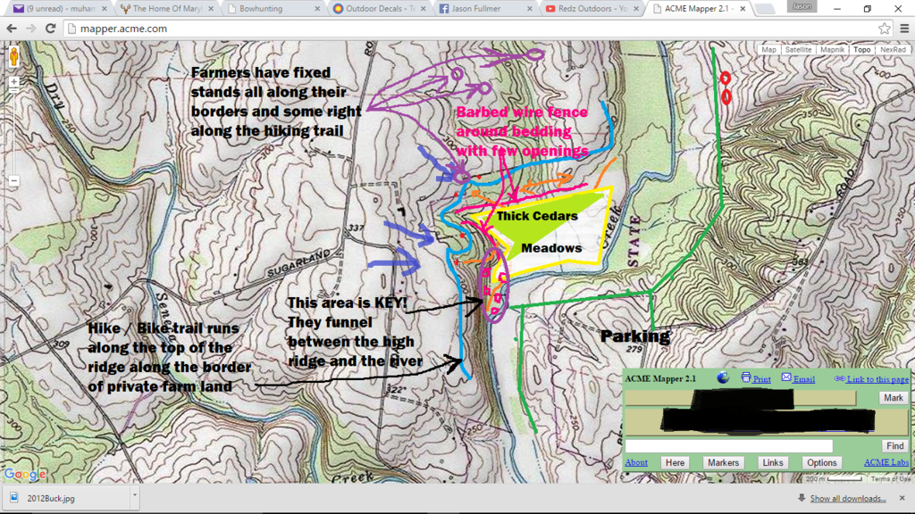
I'm helping a guy out that I met on a local hunting forum. I haven't set boots down on this spot yet, but it looks like he picked a pretty good one. I may meet him there soon to do a little tag team. I marked the red spots as possible stand locations, and the blue arrows for ideal wind conditions. What do you guys think?
Huntin, fishin, lovin everyday...
- redz
- Posts: 148
- Joined: Wed Sep 12, 2012 5:47 am
- Location: Gaithersburg, MD
- Status: Offline
Re: Public Land Topo
That big block of timber on the East side looks interesting as well.
Huntin, fishin, lovin everyday...
-
- Posts: 187
- Joined: Thu Sep 17, 2015 5:39 am
- Status: Offline
Re: Public Land Topo
I would hide your cordinates and area details in Maryland bud
[ Post made via iPhone ]
[ Post made via iPhone ]
- redz
- Posts: 148
- Joined: Wed Sep 12, 2012 5:47 am
- Location: Gaithersburg, MD
- Status: Offline
Re: Public Land Topo
I couldn't figure out how to edit or delete, so I'll post some more updated pics:
Orange lines are known deer movement. There is parking on the west side, it's about a mile hike to the middle blue wind direction arrow.
Huntin, fishin, lovin everyday...
- redz
- Posts: 148
- Joined: Wed Sep 12, 2012 5:47 am
- Location: Gaithersburg, MD
- Status: Offline
Re: Public Land Topo
Blinginpse wrote:I would hide your cordinates and area details in Maryland bud
[ Post made via iPhone ]
Done. What do you think about the spot?
Huntin, fishin, lovin everyday...
-
- Advertisement
Who is online
Users browsing this forum: No registered users and 9 guests