another topo example please

Discuss the science of figuring out our prey through good detective work.
  • Advertisement

HB Store


User avatar
backstraps
Moderator
Posts: 10122
Joined: Sun Jun 24, 2012 4:44 pm
Location: Tennessee
Status: Offline

another topo example please

Unread postby backstraps » Sat Jul 26, 2014 6:10 am

I have read on here that during the rut when a buck is cruising, on straight lined ridges they prefer to "cut the corners"

Could someone post a topo pic of a straight lined ridge with markings showing how a cruiser may cut the corners?

[ Post made via Android ] Image


dan
Site Owner
Posts: 41642
Joined: Sat Feb 13, 2010 6:11 am
Facebook: https://www.facebook.com/HuntingBeast/?ref=bookmarks
Location: S.E. Wisconsin
Contact:
Status: Offline

Re: another topo example please

Unread postby dan » Sat Jul 26, 2014 9:44 am

I wouldn't say they cut corners on straight ridges... There are no corners to cut on straight ridges. They cut corners at jogs, around draws, some pass by points, some follow the contours around points, etc.
dan
Site Owner
Posts: 41642
Joined: Sat Feb 13, 2010 6:11 am
Facebook: https://www.facebook.com/HuntingBeast/?ref=bookmarks
Location: S.E. Wisconsin
Contact:
Status: Offline

Re: another topo example please

Unread postby dan » Sat Jul 26, 2014 9:56 am

RED DOT REPRESENTS HUNTING SPOT. Blue lines are deer trails for cruising bucks. The heads of the ravines are where all the trails come together.

Image
User avatar
backstraps
Moderator
Posts: 10122
Joined: Sun Jun 24, 2012 4:44 pm
Location: Tennessee
Status: Offline

Re: another topo example please

Unread postby backstraps » Sat Jul 26, 2014 10:08 am

Okay I understand. When I re-read the post that mentioned straight lined ridges, I realized I misunderstood what the poster was speaking about. Thanks Dan
User avatar
Crazinamatese
Posts: 5602
Joined: Mon Jul 30, 2012 3:25 am
Location: Wisconsin
Status: Offline

Re: another topo example please

Unread postby Crazinamatese » Sat Jul 26, 2014 2:30 pm

Question about the north wind on the map Dan. Im assuming the buck trail is on a leeward side (south slope) and he is scent checking the rising thermals. The north winds creates this 'wind tunnel' you guys talk about as it blows over the thermals. Right?
The cave you fear hides the treasure you seek!!!
dan
Site Owner
Posts: 41642
Joined: Sat Feb 13, 2010 6:11 am
Facebook: https://www.facebook.com/HuntingBeast/?ref=bookmarks
Location: S.E. Wisconsin
Contact:
Status: Offline

Re: another topo example please

Unread postby dan » Sat Jul 26, 2014 11:05 pm

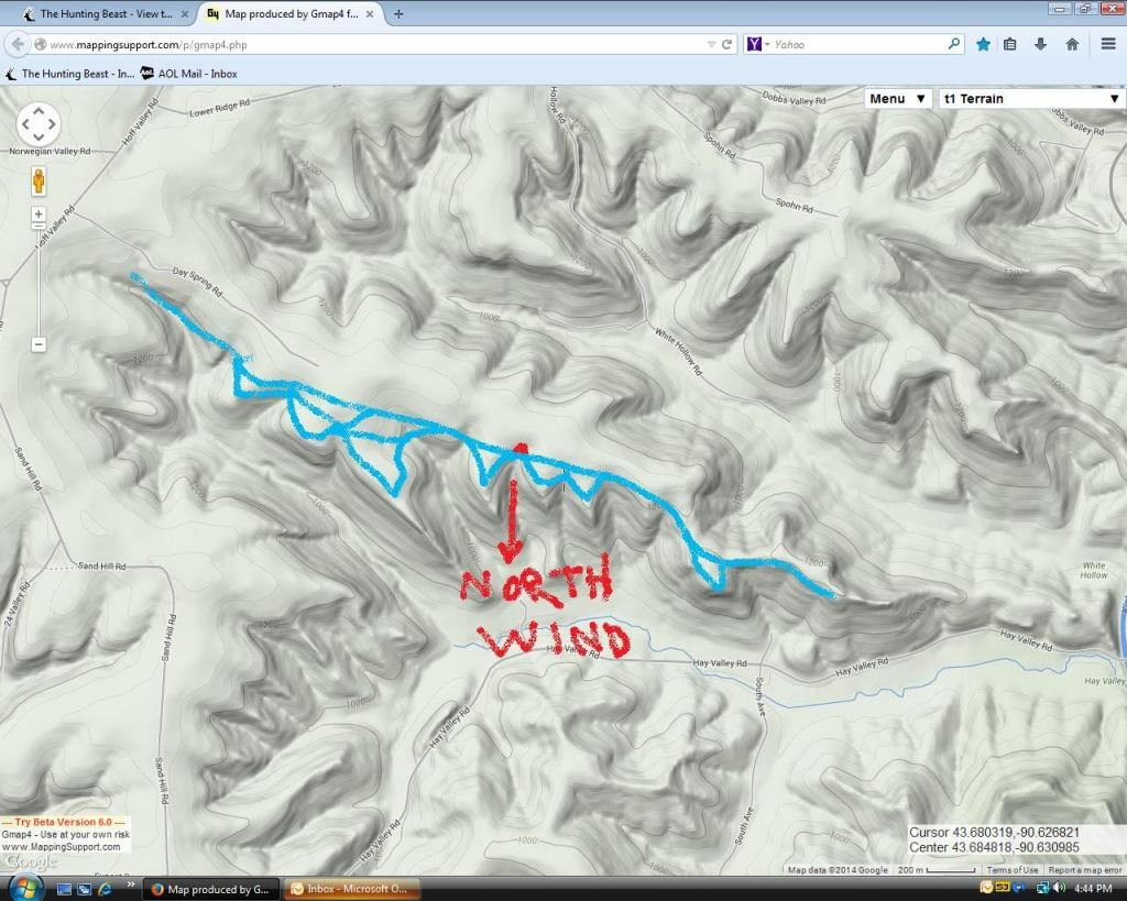
Crazinamatese wrote:Question about the north wind on the map Dan. Im assuming the buck trail is on a leeward side (south slope) and he is scent checking the rising thermals. The north winds creates this 'wind tunnel' you guys talk about as it blows over the thermals. Right?

Correct


  • Advertisement

Return to “Scouting”

Who is online

Users browsing this forum: No registered users and 35 guests