


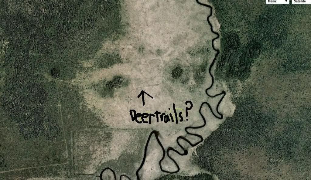
Finding deer trails from satellite photos?
-
mnbowfisherman33
- Posts: 27
- Joined: Sun Aug 07, 2011 4:58 am
- Status: Offline
-
swamp-assassin

- 500 Club
- Posts: 612
- Joined: Wed Aug 17, 2011 1:27 pm
- Location: NE Wisconsin
- Status: Offline
Re: Finding deer trails from satellite photos?
ive always assumed that they are game trails of some sort. curious to see what some others say who have more experience
"Youll take my guns when you pry them out of my cold dead hands, with the bolts locked back, the barrels smoking and a pile of empty brass and magazines at my feet." 
-
Dewey

- Moderator
- Posts: 36754
- Joined: Thu Mar 11, 2010 7:57 pm
- Location: Wisconsin
- Status: Offline
Re: Finding deer trails from satellite photos?
Yes those are more than likely deer trails. I use aerials to find deer trails in cattails all the time and have verified while scouting that they were indeed deer trails.
[ Post made via iPhone ]
[ Post made via iPhone ]
Last edited by Dewey on Thu Nov 17, 2011 4:57 pm, edited 1 time in total.
-
Dewey
- Moderator
- Posts: 36754
- Joined: Thu Mar 11, 2010 7:57 pm
- Location: Wisconsin
- Status: Offline
Re: Finding deer trails from satellite photos?
Yes those are more than likely deer trails. I know I use aerials to find deer trails in cattails all the time and have verified while scouting that they were indeed deer trails.
[ Post made via iPhone ]
[ Post made via iPhone ]
-
Swampthing

- 500 Club
- Posts: 3335
- Joined: Sat Mar 06, 2010 8:13 pm
- Location: Western Minnesota
- Status: Offline
Re: Finding deer trails from satellite photos?
Yes, those are deer trails. Good eye.
[ Post made via Android ]
[ Post made via Android ]
-
DEERSLAYER

- Super Moderator
- Posts: 8353
- Joined: Sun Mar 14, 2010 3:22 pm
- Location: Western L.P. of MI
- Contact:
- Status: Offline
Re: Finding deer trails from satellite photos?
I think those are likely deer trails since they appear to connect two pieces of drier ground and are not dark like water, but many times it's just little streams or water ways within the marsh so the only way to know for sure is boots on the ground.
You cannot invade mainland America. There would be a rifle behind every blade of grass.
Isoroku Yamamoto, Japanese Admiral
Isoroku Yamamoto, Japanese Admiral
-
Buckfever

- 500 Club
- Posts: 1029
- Joined: Fri Jan 14, 2011 3:19 pm
- Location: NE, IL
- Status: Offline
Re: Finding deer trails from satellite photos?
Sure but the problem with that, is those tend to be the main doe runs. Haven't found that to be terribly useful in terms of locating the core buck bedding.
-
BigHunt

- Posts: 12160
- Joined: Mon Jun 20, 2011 9:50 am
- Location: Wisconsin
- Status: Offline
-
headgear

- 500 Club
- Posts: 11623
- Joined: Wed Sep 08, 2010 7:21 am
- Location: Northern Minnesota
- Status: Offline
Re: Finding deer trails from satellite photos?
Yep deer trails, like mentioned above they can often be doe runs and might not be a trail a buck would use near his bed. Some of my buck bed trails do show up in aerial photos but most are very faint and I only know them from scouting or don't show up at all.
-
mnbowfisherman33
- Posts: 27
- Joined: Sun Aug 07, 2011 4:58 am
- Status: Offline
Re: Finding deer trails from satellite photos?
Well this is some interesting stuff to here, I think a scouting mission is in order this winter/spring. 
-
BigHunt
- Posts: 12160
- Joined: Mon Jun 20, 2011 9:50 am
- Location: Wisconsin
- Status: Offline
Re: Finding deer trails from satellite photos?
mnbowfisherman33 wrote:Well this is some interesting stuff to here, I think a scouting mission is in order this winter/spring.
HUNT LIKE A BEAST
-
Dewey
- Moderator
- Posts: 36754
- Joined: Thu Mar 11, 2010 7:57 pm
- Location: Wisconsin
- Status: Offline
Re: Finding deer trails from satellite photos?
I find the trails in cattails are used in the same place every year for as many years as I can remember and it's amazing over the years how the deer keep using them. Especially linking islands like you show in the pic above. The only time they change is on the edges near farmland depending on the food source.
Years ago when I first started looking at aerials these trail really stood out and really helped me out. I know quite a few people that sit off these trails in the cattails and shoot good bucks every year. That's a great tactic if you have a good idea where a buck is bedding because bucks feel comfortable moving through tall cattails during daylight.
[ Post made via iPhone ]
-
dan
- Site Owner
- Posts: 41642
- Joined: Sat Feb 13, 2010 6:11 am
- Facebook: https://www.facebook.com/HuntingBeast/?ref=bookmarks
- Location: S.E. Wisconsin
- Contact:
- Status: Offline
Re: Finding deer trails from satellite photos?
Yes... I use ariels to see deer trails in marshes often... I totally dissagree though that they are always "doe trails" On the contrary, I have found many bucks useing these trails... It all depends on if they lead to buck or doe bedding.
-
- Advertisement
Who is online
Users browsing this forum: No registered users and 24 guests