Public marsh buck #1 down
- bowhunter15
- Posts: 2289
- Joined: Wed Dec 15, 2010 3:14 pm
- Facebook: https://www.facebook.com/pages/DIY-Spor ... 3136327062
- Location: Minneapolis
- Contact:
- Status: Offline
Public marsh buck #1 down
This deer was dead about 5 minutes into the season. Shot him in the morning just after first light. He came from behind me, which was what I expected. The maple I was sitting in was completely barren of cover for about another 10 feet over my head. I stood up and turned my feet to lign up for a shot. He had me pinned and stared me down for a good 45 seconds. Finally he started walking again in the sand (must be a flooded area at some points of the year) and I was able to draw and stop him. The arrow from 22 yards center punched both lungs and the back of the heart. Though the blood was barely there, only a drop here and there, I was able to follow his tracks in the sand to where he had piled up after 80 yards. I was hunting with another friend close by. He happens to be more of a meat hunter, and since party hunting is legal in our area of minnesota under certain guidelines and we had talked about possible situations beforehand, I felt fine taking this buck, even though I'm still after a bigger one. The friend was more than happy to put his tag on it.
What made this hunt satisfying for me was that I'd never scouted this particular piece of public on foot before. I spend a few hours looking at aerial photos and picked a spot based on hunches, current weather conditions, and experience. Then I made a custom map for my GPS including a high def aerial image and path to the location I wanted to hunt. After arriving at the parking lot, I followed my pre-made route on the GPS right to the tree I wanted to hunt and set up. It was really nice to know that I'm finally getting to the point where my hunches are correct every so often. The whole purpose of this particular set up was to get a deer on the ground. I didn't expecet a mature buck to show anyways. I'm saving those hunts for afternoon sets. It sure is great to get back in the stand again and feel that adrenaline rush!
- Dewey
- Moderator
- Posts: 36751
- Joined: Thu Mar 11, 2010 7:57 pm
- Location: Wisconsin
- Status: Offline
Re: Public marsh buck #1 down
Congrats on the public marsh buck!!
Glad to hear that your plan worked out!
- RaisedByWolves
- 500 Club
- Posts: 2441
- Joined: Tue May 18, 2010 12:49 pm
- Location: WI
- Status: Offline
Re: Public marsh buck #1 down
Great Job Way to bring the plan together!
When better is possible, good is never good enough
- Liberty-Hunt
- 500 Club
- Posts: 1783
- Joined: Mon Feb 22, 2010 9:31 pm
- Facebook: https://www.facebook.com/liberty.hunt.188
- Location: FRANCE
- Contact:
- Status: Offline
Re: Public marsh buck #1 down
What a satisfaction for you!
Great end!
Great end!
"Huntingly",
L-H
GIVE ME LIBERTY OR GIVE ME DEATH!
L-H
GIVE ME LIBERTY OR GIVE ME DEATH!
-
- 500 Club
- Posts: 959
- Joined: Tue Feb 23, 2010 12:53 pm
- Status: Offline
Re: Public marsh buck #1 down
Wow, that's awesome! That's one of my favorite parts of public hunting, trying to read the terrain from a map and just going in and hunting it. Congrats on your buck. If you have time give us some more details on what kind of spot you picked and why.
- UPbowhunter
- Posts: 1041
- Joined: Tue Mar 16, 2010 8:52 am
- Facebook: todd freeman
- Location: 25'up a tree
- Status: Offline
-
- Posts: 1715
- Joined: Wed Jan 26, 2011 2:28 am
- Location: SE Wisconsin
- Status: Offline
Re: Public marsh buck #1 down
NICE!
I'm amazed you were able to pick out the EXACT TREE you wanted to hunt out of via high resolution aerials/topos. I'm amazed you were able to navigate to it in the dark having never been there before,set up (in the dark) and kill a nice buck. That is a powerful hunting system! Way to go!
Also, great idea to put this hunt together for a morning hunt just to get a deer,and saving your afternoon hunts for your prescouted buck bed hunts. I'm going to try this idea and see if I can pop off a doe without disturbing my buck beds ( I hunt Wisconsin earn a buck zone).
By the way, what source did you use for your aerial pic that you put on the gps?
-
- 500 Club
- Posts: 1032
- Joined: Wed Jul 21, 2010 5:56 am
- Location: Norcak
- Status: Offline
Re: Public marsh buck #1 down
Glad your set up worked. I think thats the first buck down from a beast member this year! Congrats man, always good to hear a fellow member have sucess.
- Indianahunter
- 500 Club
- Posts: 1774
- Joined: Sat Feb 20, 2010 2:27 pm
- Location: Greensburg Indiana
- Status: Offline
Re: Public marsh buck #1 down
Congrats on your success. I like going in on a place I have never set foot on with a topo. It's great practice and really hones your skills.
God shows his love for us in that while we were still sinners, Christ died for us.
Romans 5:8
Romans 5:8
-
- 500 Club
- Posts: 2078
- Joined: Wed Mar 17, 2010 2:18 am
- Location: Wisconsin
- Status: Offline
Re: Public marsh buck #1 down
CONGRATS!!!
- xpauliber
- 500 Club
- Posts: 1727
- Joined: Fri May 20, 2011 4:41 am
- Location: Central PA
- Status: Offline
Re: Public marsh buck #1 down
I agree with all the previous posts. Great job!
[ Post made via iPad ]
[ Post made via iPad ]
- Carol
- Site Admin
- Posts: 9054
- Joined: Fri Feb 12, 2010 6:51 am
- Status: Offline
Re: Public marsh buck #1 down
Even a blind squirrel finds a nut every now and then!
Some People Need a Shock Collar!
-
- 500 Club
- Posts: 1804
- Joined: Wed Feb 24, 2010 3:28 am
- Location: UPPER MICHIGAN
- Status: Offline
Re: Public marsh buck #1 down
Good plan,good buck!
[ Post made via Android ]
[ Post made via Android ]
- GRFox
- 500 Club
- Posts: 1657
- Joined: Mon May 24, 2010 4:59 am
- Location: New York
- Status: Offline
Re: Public marsh buck #1 down
Nice man! great job.
- bowhunter15
- Posts: 2289
- Joined: Wed Dec 15, 2010 3:14 pm
- Facebook: https://www.facebook.com/pages/DIY-Spor ... 3136327062
- Location: Minneapolis
- Contact:
- Status: Offline
Re: Public marsh buck #1 down
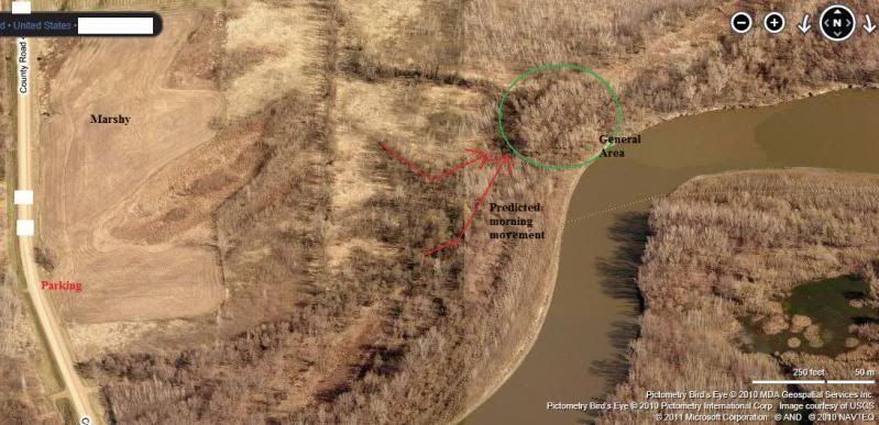
bing.com/maps - So the first image is the "big picture" image. I envision the deer coming from the area near the parking lot and the browse on the south and east side of it. As they filter back to the NE, there's a little "island" of large trees. I figured they could possibly use this as a funnel between the really thick stuff and the river on the way back to bed. I also figured, and made the decision based on the wind, that I could walk the river bank to get back there without leaving a scent trail. I always like to enter my morning sets by looping around.
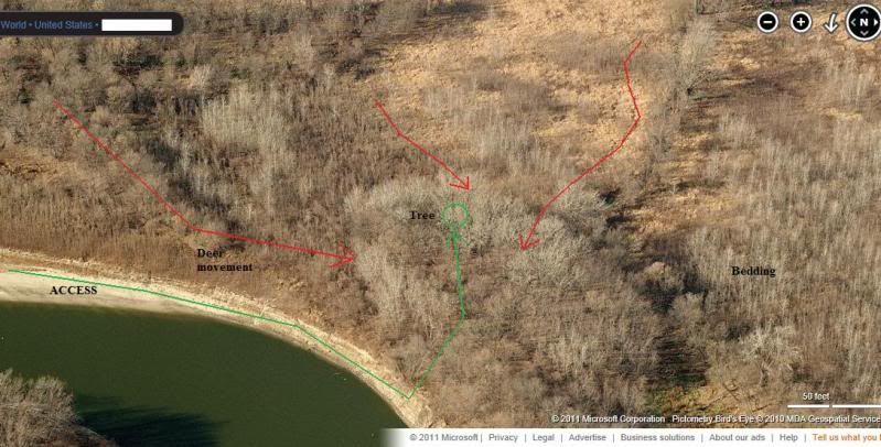
This second pic is further zoomed in on the "island". I also rotated the map. I find that rotating the map on bing.com/maps gives you a different image each time, sometimes from different times of the year and different lighting conditions, which allows you to pick up on things you missed with the first angle. You can often find exact trails going through cattails.
I picked that tree in near the front and center of the island because if you look at the scale, I'd be able to shoot anything moving through or near the edge of those big hardwoods. You can also see that river bed access better. All sand.
What suprised me was that once I actually walked into those tall trees, the ground was all sand. No brush, no grass, just big maples spread throughout. Must flood every spring and the dense canopy doesn't allow small growth? I've never seen that before, so I was initally a bit nervous about the set. But I got up in that tree, facing N (which would be facing away from the direction they'd come from). Sure enough, that buck came in from that middle red arrow. Would have been perfect for filming, since it was so open in there. Had shooting lanes out to probably 60 yards in several directions. Actually had the camera all set up, but didn't think there'd be enough light so I didn't bother. After the shot I turned the camera on and it had plently of light. O well, live and learn.
After it got light and I found the deer, I found that a better spot to sit likely would have been right on the edge of those tall open trees and the smaller trees I've labeled as "bedding". Even though I didn't see any over there, this buck probably would have made his way there, and there was a heavy trail through some tall grass right on that edge.
To put the aerial images on my GPS, I followed this tutorial:
[bbvideo=425,350]http://www.youtube.com/watch?v=0fnYEDuoT8s[/bbvideo]
Once I have the bing.com image I want, I hit the PrtSc (print screen) button. Paste it into paint and crop out all of the borders and web adress stuff, etc. Then save it as a .jpg. Then put it in google earth, resize and drag and drop into the Custom Maps folder on the GPS. I'm not sure if it only works for Garmin or not. Then you can create a route to follow on the GPS, though, in this spot, it really wasn't even necessary. I can keep doing this process with several zoomed in images side by side to do the whole marsh if I want to. Then I get free topo lines for the GPS from http://www.gpsfiledepot.com/maps/. They show up right on top of the custom map image I've put on there. While not necessary for marsh hunting, they do help a lot for hill country. Beats buying Garmin's topo chip for like $100 or whatever it is.
Last edited by Carol on Mon Sep 19, 2011 4:21 am, edited 1 time in total.
Reason: edited for video player
-
- Advertisement
Who is online
Users browsing this forum: 218er and 39 guests