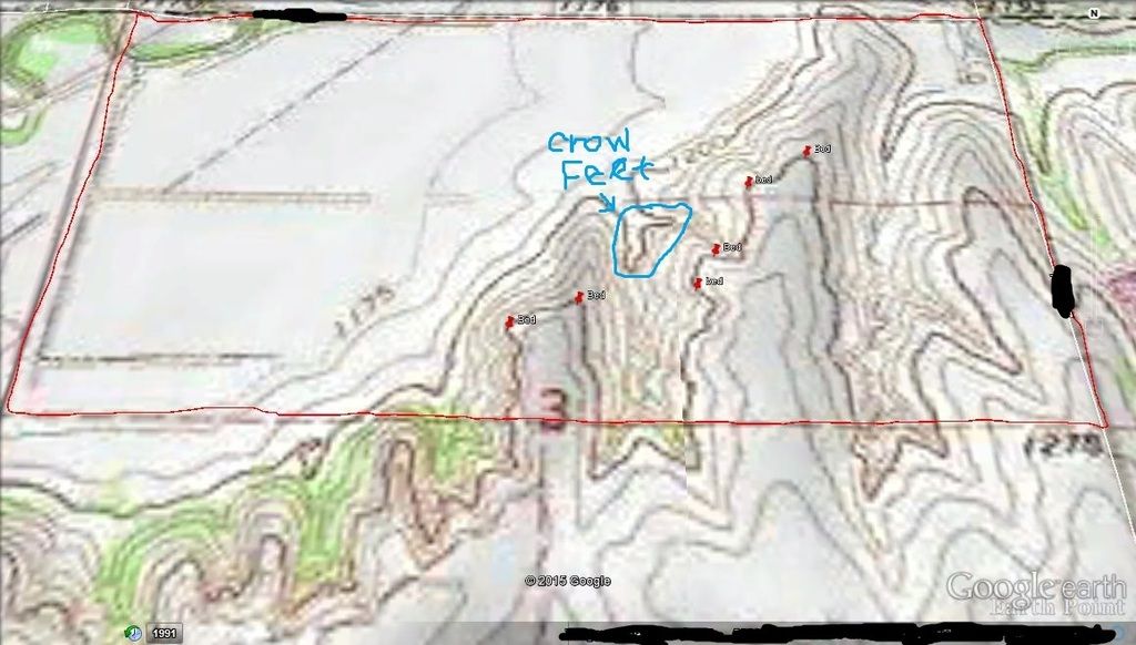
Okay I have been reading a ton of posts from Autumn Ninja and Crazinmanateze about topo maps. I have attached a topo map and an aerial of a place that I have hunted in the past. In the topo map, I feel like I have a pretty good grasp of where I would expect mature bucks to bed. Obviously these beds would be based on the wind direction, but most work with a South, Southwest or West wind (which are the predominant winds for this area). Can someone tell me if I am on with where expected bedding is according to the topo? Is this an example of the crow's feet or thermal hub that AN talks about?
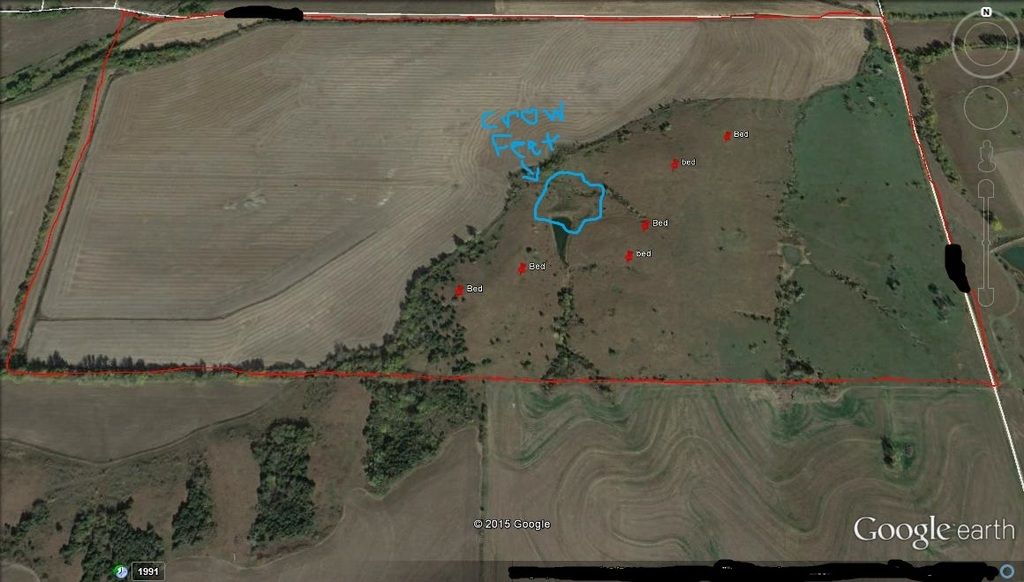
Then my next questions are on the aerial. As you can see from where the red bed marks are, most of these points are in the middle of nowhere. There aren't any trees around most of these potential bedding sights. Last year, this open area was knee high prairie grass. I can understand how great a bucks advantage is in the spots due to overlooking the entire bottom field(s) below, but would a mature buck bed in the wide open like this?
???s about spurs, points, crow's feet, etc.
- SHoff10
- Posts: 126
- Joined: Thu Oct 04, 2012 1:48 am
- Status: Offline
???s about spurs, points, crow's feet, etc.
“If some animals are good at hunting and others are suitable for hunting, then the Gods must clearly smile on hunting.” –Aristotle
-
- Site Owner
- Posts: 41641
- Joined: Sat Feb 13, 2010 6:11 am
- Facebook: https://www.facebook.com/HuntingBeast/?ref=bookmarks
- Location: S.E. Wisconsin
- Contact:
- Status: Offline
Re: ???s about spurs, points, crow's feet, etc.
That is not a "crows foot" ... Its in a valley, crow foot would be at the top of the elevation.
to answer Your second question: Would a mature buck bed in tall grass in an over looked area? Absolutely. Are they on this property? Pressure, quality of bedding, and a host of other factors will determine that, and your going to need to go out there and find out for yourself if they actually are doing that there now.
- Crazinamatese
- Posts: 5602
- Joined: Mon Jul 30, 2012 3:25 am
- Location: Wisconsin
- Status: Offline
Re: ???s about spurs, points, crow's feet, etc.
Looks like a real tight draw. Interesting terrain feature though.
The cave you fear hides the treasure you seek!!!
- SHoff10
- Posts: 126
- Joined: Thu Oct 04, 2012 1:48 am
- Status: Offline
Re: ???s about spurs, points, crow's feet, etc.
Thanks for the quick responses and clarification. I have seen a good buck bed on one of the far northwestern points when trying to access from below through the big field. The field is in a bottom and as soon as we pulled our truck to the edge of the field, he bolted back to the south, up and over the Ridge top.
Was I correct in putting the potential bedding sites where I did?
[ Post made via Android ]
Was I correct in putting the potential bedding sites where I did?
[ Post made via Android ]
“If some animals are good at hunting and others are suitable for hunting, then the Gods must clearly smile on hunting.” –Aristotle
-
- Posts: 32
- Joined: Thu Jan 24, 2013 12:31 pm
- Status: Offline
Re: ???s about spurs, points, crow's feet, etc.
When you are studying topo maps keep in mind that you can display topo lines on the Google aerial. For example:
http://www.mappingsupport.com/p/gmap4.p ... tour_lines
I am the developer of Gmap4 which is an enhanced Google map viewer. This project is a public service and part of my way to "pay it forward".
Simply open the above map and zoom/drag it to your area of interest. Or use Menu ==> Search.
To toggle the contour lines on/off click the basemap button (next to the "Menu" button). Then under the "Overlay" heading, click "USA_contour_lines".
For more info, check out the Gmap4 homepage: http://www.mappingsupport.com/p/gmap4.html
Joseph
-
- Site Owner
- Posts: 41641
- Joined: Sat Feb 13, 2010 6:11 am
- Facebook: https://www.facebook.com/HuntingBeast/?ref=bookmarks
- Location: S.E. Wisconsin
- Contact:
- Status: Offline
Re: ???s about spurs, points, crow's feet, etc.
Jelf wrote:When you are studying topo maps keep in mind that you can display topo lines on the Google aerial. For example:
http://www.mappingsupport.com/p/gmap4.p ... tour_lines
I am the developer of Gmap4 which is an enhanced Google map viewer. This project is a public service and part of my way to "pay it forward".
Simply open the above map and zoom/drag it to your area of interest. Or use Menu ==> Search.
To toggle the contour lines on/off click the basemap button (next to the "Menu" button). Then under the "Overlay" heading, click "USA_contour_lines".
For more info, check out the Gmap4 homepage: http://www.mappingsupport.com/p/gmap4.html
Joseph
Thank's Joseph, I use your website a lot and pass it on a lot... Its one of my favorites.
-
- Site Owner
- Posts: 41641
- Joined: Sat Feb 13, 2010 6:11 am
- Facebook: https://www.facebook.com/HuntingBeast/?ref=bookmarks
- Location: S.E. Wisconsin
- Contact:
- Status: Offline
Re: ???s about spurs, points, crow's feet, etc.
Was I correct in putting the potential bedding sites where I did?
Your dots look good for south or East winds
- SHoff10
- Posts: 126
- Joined: Thu Oct 04, 2012 1:48 am
- Status: Offline
Re: ???s about spurs, points, crow's feet, etc.
Thanks again Dan and thank you Jelf. I really appreciate the info. I love looking at aerials and am now learning how to read topo maps.
[ Post made via Android ]
[ Post made via Android ]
“If some animals are good at hunting and others are suitable for hunting, then the Gods must clearly smile on hunting.” –Aristotle
- Country
- 500 Club
- Posts: 1218
- Joined: Sat Sep 28, 2013 5:41 am
- Location: Wisconsin
- Status: Offline
Re: ???s about spurs, points, crow's feet, etc.
Jelf wrote:When you are studying topo maps keep in mind that you can display topo lines on the Google aerial. For example:
http://www.mappingsupport.com/p/gmap4.p ... tour_lines
I am the developer of Gmap4 which is an enhanced Google map viewer. This project is a public service and part of my way to "pay it forward".
Simply open the above map and zoom/drag it to your area of interest. Or use Menu ==> Search.
To toggle the contour lines on/off click the basemap button (next to the "Menu" button). Then under the "Overlay" heading, click "USA_contour_lines".
For more info, check out the Gmap4 homepage: http://www.mappingsupport.com/p/gmap4.html
Joseph
I too really like Gmap4...this is a really good tip, I didn't know you could do this. Thanks...awesome!
-
- Posts: 32
- Joined: Thu Jan 24, 2013 12:31 pm
- Status: Offline
Re: ???s about spurs, points, crow's feet, etc.
Thanks for the kind words.
In addition to topos and aerials there is a ton of GIS data online that is useful to people who enjoy the outdoors. I have made a number of Gmap4 links that can display a bunch of that GIS data. Scroll down on this page to find those links:
http://www.propertylinemaps.com/p/public_land_map.html
This coming winter I plan to make links for additional states.
===> Be sure to click "About this map" in the upper left corner so you know how to use the map.
Joseph
-
- Advertisement
Who is online
Users browsing this forum: WanderingFarmer and 75 guests