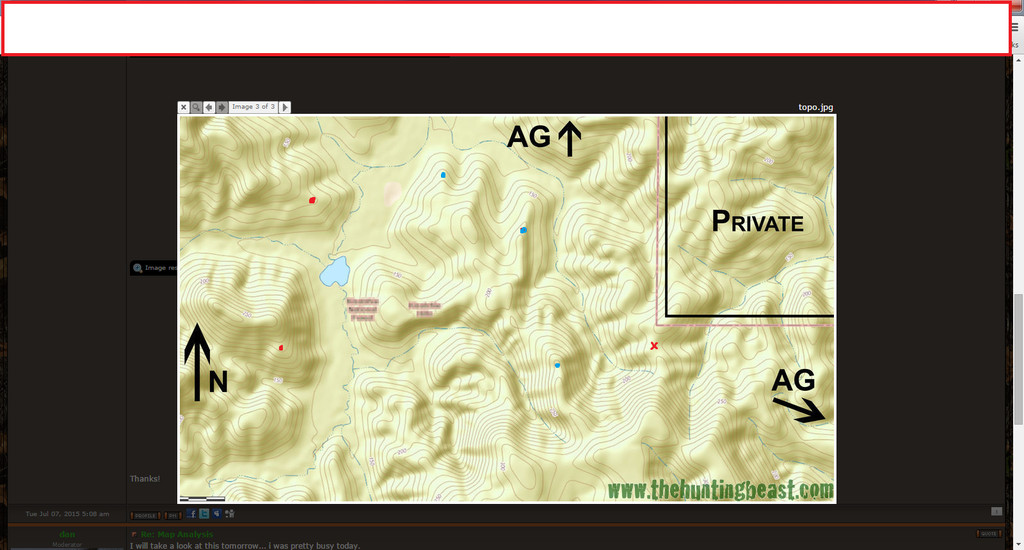
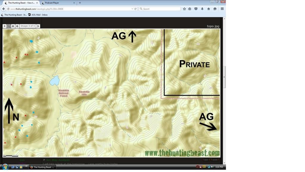
Would love to see this map marked up by some fellow beasts. I have some ideas but would like to wait on feedback. This is 3 images of the same terrain. The flat area in the middle-left of each pic is a hardwood creek bottom that runs north/south through the area that's full of acorns. It dissipates on the southern end of map and branches out into the hills. There's a few east/west branches off of it that you can see. The ridges are mixed hardwoods and conifers. Some of the ridge tip-tops have barren rock outcroppings with open overstory. The rest is closed canopy forest. Agricultural fields are just off the map where the hills drop down into flat, riverbottom land that's at the same elevation of the hardwood creek bottom.
• Scale: Maps are about 2 miles wide and 1 mile tall.
• Movement pattern is creek bottom/ag to ridge tops in the morning (food to bed) and reverse in evening. Ag is long harvested by hunting season but is usually re-planted in wheat or ryegrass.
• Prevailing winds in the Fall are out of the NW or SE 50/50.
How would bucks cruise these ridges in the pre-rut and rut searching does?
What edges would they work in morning back to bed?
Conversely, how would animals descend off the tops down to bottoms to feed in afternoons?
Can you identify some primary bedding points and rut funnels?
Would love to hear your reasonings for each area in detail.
Thanks!
Map Analysis
-
- Posts: 48
- Joined: Thu May 30, 2013 11:39 am
- Status: Offline
-
- Site Owner
- Posts: 41642
- Joined: Sat Feb 13, 2010 6:11 am
- Facebook: https://www.facebook.com/HuntingBeast/?ref=bookmarks
- Location: S.E. Wisconsin
- Contact:
- Status: Offline
Re: Map Analysis
I will take a look at this tomorrow... i was pretty busy today.
- Twenty Up
- 500 Club
- Posts: 1885
- Joined: Sat Oct 25, 2014 1:06 pm
- Location: Dirty South
- Status: Offline
Re: Map Analysis
I gave it a shot, take it with a grain of salt thought I'm still a novice internet scouter. Maybe this will give you a different perspective if nothing else.
Red= Possible NW beds
Blue= Possible SE Beds
Red X= Good stand site
Trust the Process~~ Lost Boys Outdoors ~~
YoutTube: https://youtube.com/channel/UC7TXknGut5WfZQ6CbddgqYg
-
- Posts: 223
- Joined: Sat Mar 14, 2015 7:22 am
- Status: Offline
Re: Map Analysis
I'll bite. I would divide the property into quadrants to really break down each area. Look for major trails to be along the side ridges, just below the top. Also look to find rub line on the hill tops going off the tips of points. Rub and scrape lines to be in the bottoms along the creeks. I would not spend much time hunting the bottoms, likely this is where the most visible sign will be (rubs, scrapes), but mostly night time activity. Plus winds will be to variable. I'd expect deer to fall right off those points into the bottoms to feed, and vice versa. Things can be tough when u have a vertical feed-bed pattern like that. Don't right off those rocks at the tops of ridges, deer could be bedding on them. I marked beds I'd check first in red. I also marks good transition saddles in blue. I'd start by walking creeks and roads looking for tracks/ trails crossing them. Then relate that info to the suspected beds and saddle, looking for correlations. Then look at transitions for big buck sign/ high traffic sign. Then correlate everything you've learned w suspected bedding. Now that you've narrowed down the best bedding. Go find those beds. Then you can expand your search and find the secondary bedding. I'd place stand in higher elevation as much as possible. Hunt above high cuts, and saddles between bedding during the rut. Pre rut try to get close to bedding. It's tough with a vertical pattern tho. You can try to hunt below the beds but it's gunna be really tough. I'd probly save the best bedding for pre rut/rut. And hunt the nearest funnels (high cuts and saddles). U might give it one early bow shot. Trail cams could help you narrow some stuff down..
[ Post made via iPhone ]
[ Post made via iPhone ]
-
- Posts: 355
- Joined: Fri Mar 06, 2015 12:08 pm
- Status: Offline
Re: Map Analysis
Bump
[ Post made via Android ]
[ Post made via Android ]
-
- Site Owner
- Posts: 41642
- Joined: Sat Feb 13, 2010 6:11 am
- Facebook: https://www.facebook.com/HuntingBeast/?ref=bookmarks
- Location: S.E. Wisconsin
- Contact:
- Status: Offline
Re: Map Analysis
Ok, here is my take... North west or south winds. I would purposefully bump the beds along the edge of the valley your saying the deer are using... I would then concentrate on the bedding that looks better to me further back from the valley. I marked potential beds in red, I marked possible hunting spots in blue. However, I would let scouting determine exact ambush spots.
-
- Posts: 48
- Joined: Thu May 30, 2013 11:39 am
- Status: Offline
Re: Map Analysis
dan wrote:I would purposefully bump the beds along the edge of the valley your saying the deer are using... I would then concentrate on the bedding that looks better to me further back from the valley.
Thanks guys! Any more takers? Dan, that's actually something I'd considered. However, public access is from the west, so effectively, they'd be doing it for me. Most folks don't get across that bottom to hunt the east side hills between the bottom and the private because it's too far. I was planning on concentrating in this area first. I've actually done some hunting on the side you marked and have seen fair sign/deer in some of those saddles. I am very interested in the middle section (east of creek), because pressure from the west naturally stacks the deer in there. I would be approaching from alternate directions than the masses.
[ Post made via iPhone ]
-
- Site Owner
- Posts: 41642
- Joined: Sat Feb 13, 2010 6:11 am
- Facebook: https://www.facebook.com/HuntingBeast/?ref=bookmarks
- Location: S.E. Wisconsin
- Contact:
- Status: Offline
Re: Map Analysis
burkhart wrote:Dan
Is there a reason u only marked tht side? Also when hunting hill country like this is it Better to stick to saddles for ambush than attacking each point? Or would you let scouting and beds determine that?
Being I'm not stealthy, relatively clumsy and blind to beds would hunting the pinched cuts and saddles be effective?
[ Post made via iPhone ]
There is not much that looks like good bedding for the winds menmtioned for deer feeding in that valley to the East of it... If I saw sign of a shooter coming from that direction i would take a new look at that side. I probably could of marked a few spots over there two, but the other side really layed out nice for those winds, those beds, and the ambushes.
-
- Site Owner
- Posts: 41642
- Joined: Sat Feb 13, 2010 6:11 am
- Facebook: https://www.facebook.com/HuntingBeast/?ref=bookmarks
- Location: S.E. Wisconsin
- Contact:
- Status: Offline
Re: Map Analysis
Apex wrote:dan wrote:I would purposefully bump the beds along the edge of the valley your saying the deer are using... I would then concentrate on the bedding that looks better to me further back from the valley.
Thanks guys! Any more takers? Dan, that's actually something I'd considered. However, public access is from the west, so effectively, they'd be doing it for me. Most folks don't get across that bottom to hunt the east side hills between the bottom and the private because it's too far. I was planning on concentrating in this area first. I've actually done some hunting on the side you marked and have seen fair sign/deer in some of those saddles. I am very interested in the middle section (east of creek), because pressure from the west naturally stacks the deer in there. I would be approaching from alternate directions than the masses.
[ Post made via iPhone ]
Now, knowing that, I would look further East too...
-
- Advertisement
Who is online
Users browsing this forum: Google [Bot] and 18 guests