


I know there are a pretty good handful of beast members that are utilizing gps for scouting and navigating, and with the pro version of google earth you can import and export tracks and waypoints as overlays.
This is a link to a free(2 year I think) trial of google earth pro. I think their servers are getting overloaded and I had to hit f5 and resend the page about 10 times before it went through, but it works awesome. Hopefully the link works and it will help fellow beast members out.
http://slickdeals.net/?pv=&au=&sdtid=76 ... trial.html
Google earth pro...free
-
darenative
- Posts: 193
- Joined: Fri Jan 27, 2012 8:30 am
- Status: Offline
-
Horizontal Hunter
- 500 Club
- Posts: 2938
- Joined: Thu Jul 31, 2014 1:08 pm
- Location: Western Massachusetts
- Status: Offline
Re: Google earth pro...free
Thanks for the link.
Bob
[ Post made via iPad ]
Bob
[ Post made via iPad ]
Vegetarian: vejiˈte(ə)rēən/noun: old Indian word for lousy hunter. 
Excalibur Exocet, GT Laser II, 2" Bhoning Blazers 125g NAP Spitfire
Excalibur Exocet, GT Laser II, 2" Bhoning Blazers 125g NAP Spitfire
-
Bigb

- 500 Club
- Posts: 937
- Joined: Sun Jun 17, 2012 5:12 am
- Status: Offline
Re: Google earth pro...free
I downloaded the Pro yesterday but haven't seen any difference with the regular goggle earth. Did you see any difference at all?
-
darenative
- Posts: 193
- Joined: Fri Jan 27, 2012 8:30 am
- Status: Offline
Re: Google earth pro...free
Bigb, when I connect my garmin 62 via usb cable I can import waypoints and tracks and they are overlayed onto Pro and they are not importable on regular google earth. I believe you can also export custom tracks and waypoints to your supported gps device. There is also a bunch of tool functions and editing functions that don't exist in regular GE. Resolution on images that are printed is better in Pro GE. I've only messed with it for about 15 minutes, so I'm sure there is more features that I haven't discovered.
-
frogtosser
- Posts: 42
- Joined: Sat Jul 26, 2014 3:44 pm
- Location: Sartell, MN
- Status: Offline
Re: Google earth pro...free
What did you use as a company name and job?
-
darenative
- Posts: 193
- Joined: Fri Jan 27, 2012 8:30 am
- Status: Offline
Re: Google earth pro...free
frogtosser wrote:What did you use as a company name and job?
I guess you could use pretty much anything. I used my company name and job title.
-
bowhunter15

- Posts: 2289
- Joined: Wed Dec 15, 2010 3:14 pm
- Facebook: https://www.facebook.com/pages/DIY-Spor ... 3136327062
- Location: Minneapolis
- Contact:
- Status: Offline
Re: Google earth pro...free
frogtosser wrote:What did you use as a company name and job?
I put "n/a" and "n/a" and "Media" for the type.
-
stash59

- Moderator
- Posts: 10078
- Joined: Thu Nov 27, 2014 8:22 am
- Location: S Central Wi.
- Status: Offline
Re: Google earth pro...free
Thanks for the link.
-
darenative
- Posts: 193
- Joined: Fri Jan 27, 2012 8:30 am
- Status: Offline
Re: Google earth pro...free
Bowhunter15 is the resident tech junkie, he will no doubt have the program wired in short order. Maybe he will show us old timers a few tricks to get the most out of GE pro...maybe a short video tutorial 
-
Wapiti
- Posts: 432
- Joined: Thu May 08, 2014 12:58 am
- Status: Offline
Re: Google earth pro...free
GE Pro also shows parcel boundaries and provides limited parcel information in many, but not all, states.
-
nater

- Posts: 134
- Joined: Sun Jan 27, 2013 12:18 pm
- Location: SW Minnesota
- Status: Offline
Re: Google earth pro...free
Pro also lets you measure area, which is really helpful. Normal Google Earth only lets you measure distance of a line.
-
Florida

- 500 Club
- Posts: 996
- Joined: Tue Jun 24, 2014 3:20 am
- Facebook: facebook.com/huntinggeardeals
- Location: I'll give you 1 guess.
- Contact:
- Status: Offline
Re: Google earth pro...free
Signed up. Thanks for sharing!
[ Post made via Android ]
[ Post made via Android ]
http://www.huntinggeardeals.com
Co-Host Down South Hunting Podcast
Co-Host Down South Hunting Podcast
-
KLEMZ
- Posts: 1715
- Joined: Wed Jan 26, 2011 2:28 am
- Location: SE Wisconsin
- Status: Offline
Re: Google earth pro...free
Thanks for the info about GE pro being free. So far, the only real advantage I have discovered ( over regular GE), is the ability to save the screen aerial image as a HIGH RESOLUTION JPG. This is significant to me because I can zoom out and cover a bigger area on an aerial while in GE pro (what you see on your computer screen is what you get), save it, and still have the high resolution thru out the whole picture!
i.e. I can now make custom aerials for my garmin gps using any google earth aerial..yet have the convenience of covering much larger areas (4x's larger) per map.
In a nutshell..
- get your picture on screen in GE pro
- select..save image.. from tool bar at top
- select..maximum resolution (4800x3330).. then save image
- select..add image overlay..from top tool bar..browse to your picture and select..open
-adjust transparency to 50% so you see both images, and line up as best you can (this is actually very accurate)
-once lined up..slide transparency back to full opaque and click..ok
- At left sidebar find your new overlayed image and select..save place as.. select KMZ
-find your new KMZ file (i put mine in my documents) and select..open with..then select..Google Earth..this allows you to verify your new aerial is properly lined up with GE
-normally, you could simply put this KMZ in your garmins CustomMaps folder, BUT, it is too big for the gps to read..so
-use G-Raster (super simple software $5) to break the big KMZ into smaller tiles your garmin can read..this literally takes only a couple mouse clicks
I realize alot of guys could care less about all this geeky mapping stuff, and thats great. But for guys who use their gps for more efficient scouting and navigating, it is nice to be able to have the best possible aerials available. I personally don't use a smart phone for scouting.
Last edited by KLEMZ on Sun Feb 08, 2015 7:37 am, edited 1 time in total.
-
Thermals

- 500 Club
- Posts: 1097
- Joined: Tue Dec 03, 2013 2:58 pm
- Location: Next to a Bed
- Status: Offline
Re: Google earth pro...free
I do appreciate this info, I would love to have aerial on my gps. I think the Birdseye from garmin is junk
[ Post made via iPhone ]
[ Post made via iPhone ]
-
mobowhunter77

- Posts: 88
- Joined: Sat Dec 27, 2014 2:12 am
- Location: Missouri
- Status: Offline
Re: Google earth pro...free
darenative wrote:Bigb, when I connect my garmin 62 via usb cable I can import waypoints and tracks and they are overlayed onto Pro and they are not importable on regular google earth. I believe you can also export custom tracks and waypoints to your supported gps device. There is also a bunch of tool functions and editing functions that don't exist in regular GE. Resolution on images that are printed is better in Pro GE. I've only messed with it for about 15 minutes, so I'm sure there is more features that I haven't discovered.
Just FYI. I'm able to do everything you mentioned here with the regular Google Earth. Thanks to bowhunter15 for his tutorial.
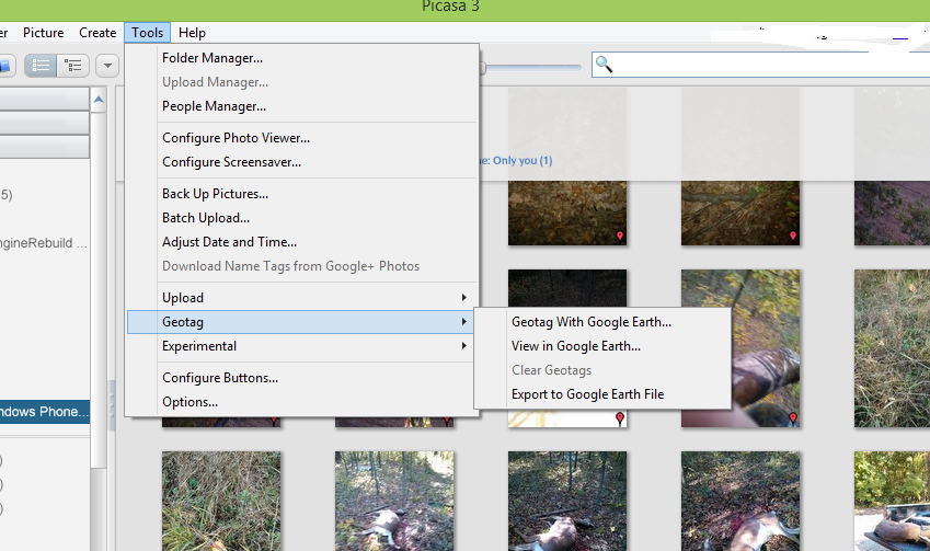
I'm also able to geotag my photo taken at each location using Picasa3. I think picasa is now own by google.
Just download picasa then select a photo and click geotag on one of the menu bar (can't remember which right now). [s]I'll post a photo later when I have a chance[/s].
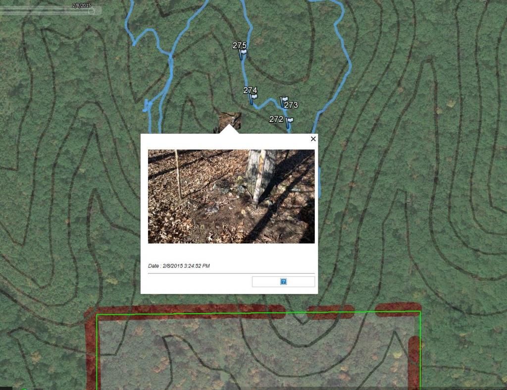
Here you go.
1. select the photo then go tools->geotag-> geotag with google earth.
2. If your camera has a gps built like most phones it will place the photo in the right spot or close to it.
3. If not you will have to center it using the zoom (mouse wheel) by centering the cross hair on the location you took the photo in google earth.
4. then click geotag.
Here's a sample.
-
- Advertisement
Who is online
Users browsing this forum: adrenalin, dan, Evanszach7, Ghost Hunter and 58 guests