

Topographical terms and descriptions

-
PApublic1187

- 500 Club
- Posts: 582
- Joined: Wed Aug 18, 2021 9:02 am
- Location: Northeast PA
- Status: Offline
Re: Topographical terms and descriptions
Unbelievable thread!! Read the whole thread in it's entirety and wow, completely will change the way I approach now understanding thermals a bit better.
Nothing beats some tree therapy. Deer sightings or not
-
Abishai

- Posts: 317
- Joined: Tue May 31, 2016 8:53 pm
- Location: Fort Riley, KS via AR River Valley
- Status: Offline
Re: Topographical terms and descriptions
Time for another free bump for a very informative and helpful thread!
“If you consider an unsuccessful hunt to be a waste of time, then the true meaning of the chase eludes you all together.”– Fred Bear
-
Usi05
- Posts: 385
- Joined: Thu Oct 08, 2020 11:11 am
- Status: Offline
Re: Topographical terms and descriptions
Just finished reading mapping trophy bucks and now looking at this thread again is super helpful!
Finally starting to pull it all together
Finally starting to pull it all together
-
Findian
- 500 Club
- Posts: 989
- Joined: Mon Oct 12, 2015 1:19 pm
- Location: Wisconsin
- Status: Offline
Re: Topographical terms and descriptions
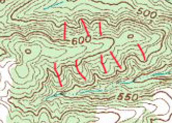
PK_ wrote:Ok this is very rough and not everything is marked it’s just to give an idea. The high crows feet in this map aren’t perfect, these hills aren’t very big so it’s hard but hopefully it is enough to illustrate…
Yellow. Some of the general anticipated daytime buck rut cruising.
Green. Converging hub.
Black. Saddle.
Red. High crows feet and falling thermals.
Blue. Dot is roughly the social hub, lines are falling thermal directions.

I’m not a good rut hunter, I’m just wondering why you think that the yellow by the green converging hub will have daytime buck movement. Is it because it looks like it be an area for doe bedding. Or a feed area. And also how would you hunt something like that.
-
PK_

- 500 Club
- Posts: 6898
- Joined: Tue Nov 20, 2012 5:10 am
- Location: Just Off
- Status: Offline
Re: Topographical terms and descriptions
Findian wrote:PK_ wrote:Ok this is very rough and not everything is marked it’s just to give an idea. The high crows feet in this map aren’t perfect, these hills aren’t very big so it’s hard but hopefully it is enough to illustrate…
Yellow. Some of the general anticipated daytime buck rut cruising.
Green. Converging hub.
Black. Saddle.
Red. High crows feet and falling thermals.
Blue. Dot is roughly the social hub, lines are falling thermal directions.
I’m not a good rut hunter, I’m just wondering why you think that the yellow by the green converging hub will have daytime buck movement. Is it because it looks like it be an area for doe bedding. Or a feed area. And also how would you hunt something like that.
Daytime movement will depend on pressure of course. But that is just a basic example of different lines of travel bucks will take when cruising along a ridge. Generally they are up pretty high during the day. But the exact elevation will depend on the terrain, cover and sometimes how the wind is behaving at that time. But in most cases I have found the mature bucks to cruise a bit lower in elevation(when side-hilling) than the majority of deer movement.
Yes that is typically the bedding elevation, so in most cases it makes no sense for a buck to cruise a bottom if the thermals are rising and the does are bedded high. Unless you have some kind of parallel trail down there where he can cut the doe trails coming on/off the hill, or the conditions are pushing or swirling that wind into the bottom…
Of course they will cross bottoms like what is shown by my other set of yellow travel routes and they will also work the bottoms of ditches to cross ridges, typically near a saddle.
How I would hunt that area would depend on a lot of other factors but in general, I would be looking to setup where 2 or more of those different travel routes cross or I would be setup near what I felt was the most secure area for a mature buck, somewhere that I could gain a wind advantage or somewhere that I feel a buck would be vulnerable.
If I wanted to hunt the converging hub specifically, I would likely setup on one of the spots where the trails merge, I would want to be on the leeward side, hanging right on a steep drop off and I would access from directly below my setup if possible.
No Shortcuts. No Excuses. No Regrets.
Everybody's selling dreams. I'm too cheap to buy one.
Everybody's selling dreams. I'm too cheap to buy one.
Rich M wrote:Typically, hunting FL has been like getting a root canal
-
Dpoole90
- Posts: 356
- Joined: Mon Oct 04, 2021 4:56 am
- Location: Central IL
- Status: Offline
Re: Topographical terms and descriptions
PK_ wrote:Findian wrote:PK_ wrote:Ok this is very rough and not everything is marked it’s just to give an idea. The high crows feet in this map aren’t perfect, these hills aren’t very big so it’s hard but hopefully it is enough to illustrate…
Yellow. Some of the general anticipated daytime buck rut cruising.
Green. Converging hub.
Black. Saddle.
Red. High crows feet and falling thermals.
Blue. Dot is roughly the social hub, lines are falling thermal directions.
I’m not a good rut hunter, I’m just wondering why you think that the yellow by the green converging hub will have daytime buck movement. Is it because it looks like it be an area for doe bedding. Or a feed area. And also how would you hunt something like that.
Daytime movement will depend on pressure of course. But that is just a basic example of different lines of travel bucks will take when cruising along a ridge. Generally they are up pretty high during the day. But the exact elevation will depend on the terrain, cover and sometimes how the wind is behaving at that time. But in most cases I have found the mature bucks to cruise a bit lower in elevation(when side-hilling) than the majority of deer movement.
Yes that is typically the bedding elevation, so in most cases it makes no sense for a buck to cruise a bottom if the thermals are rising and the does are bedded high. Unless you have some kind of parallel trail down there where he can cut the doe trails coming on/off the hill, or the conditions are pushing or swirling that wind into the bottom…
Of course they will cross bottoms like what is shown by my other set of yellow travel routes and they will also work the bottoms of ditches to cross ridges, typically near a saddle.
How I would hunt that area would depend on a lot of other factors but in general, I would be looking to setup where 2 or more of those different travel routes cross or I would be setup near what I felt was the most secure area for a mature buck, somewhere that I could gain a wind advantage or somewhere that I feel a buck would be vulnerable.
If I wanted to hunt the converging hub specifically, I would likely setup on one of the spots where the trails merge, I would want to be on the leeward side, hanging right on a steep drop off and I would access from directly below my setup if possible.
Thats an awesome explanation.
-
wolverinebuckman

- 500 Club
- Posts: 2765
- Joined: Fri Dec 08, 2017 11:55 am
- Location: S Kentucky
- Status: Offline
Re: Topographical terms and descriptions
Just wanted to send this to the top.. such a good thead! I never cared one bit about topography in SE Michigan, not until I moved to Kentucky. It's definitely been gold since I've gotten here.
Bummer of a birthmark, Hal.
-
PApublic1187
- 500 Club
- Posts: 582
- Joined: Wed Aug 18, 2021 9:02 am
- Location: Northeast PA
- Status: Offline
Re: Topographical terms and descriptions
Autumn Ninja wrote:Spurs are small ridges, points, or fingers that kick off the side of a main ridge.
Is autumn ninja still around?
Nothing beats some tree therapy. Deer sightings or not
-
- Advertisement
Who is online
Users browsing this forum: Google [Bot], Hilts and 88 guests