Topo maps with aerial view

Discuss deer hunting tactics, Deer behavior. Post your Hunting Stories, Pictures, and Questions/Answers.
  • Advertisement

HB Store


Kabic
Posts: 37
Joined: Sun Nov 21, 2010 5:54 am
Location: Western Wisconsin
Status: Offline

Topo maps with aerial view

Unread postby Kabic » Wed Nov 07, 2012 7:01 am

Not sure if you guys have seen this before, but I do remember a discussion on here about maps with Topos and aerials.

I read this blog http://eksfiles.net/2008/05/free-downlo ... -the-usgs/

which lead me to USGS site where you can download PDF files of the 2010 topographical map with aerial photo. Click "Map Locator & Downloader" link and follow the directions

http://store.usgs.gov

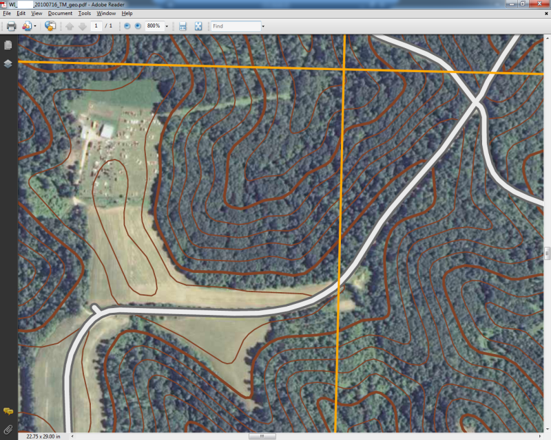
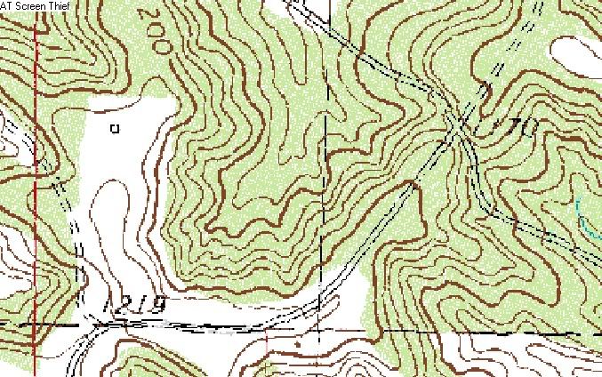
Here is a sample of the area I hunt. Notice that his zoomed in 800%. it is a rather large PDF. I think the coutour lines are not as detailed as the older Topo map, but still pretty cool.

Image


Kabic
Posts: 37
Joined: Sun Nov 21, 2010 5:54 am
Location: Western Wisconsin
Status: Offline

Re: Topo maps with aerial view

Unread postby Kabic » Wed Nov 07, 2012 7:11 am

Here is the older Topo for the same area, as you can see the image above has seemed to smooth out some of the more jagged ridges

Image
dan
Site Owner
Posts: 41642
Joined: Sat Feb 13, 2010 6:11 am
Facebook: https://www.facebook.com/HuntingBeast/?ref=bookmarks
Location: S.E. Wisconsin
Contact:
Status: Offline

Re: Topo maps with aerial view

Unread postby dan » Wed Nov 07, 2012 8:51 pm

I think its important to see those jagged ridge definitions because with that you can tell exactly where the buck beds will be, as long as the topo is accurate... But it is also nice to be able to see the timber and the elevation at the same time.
User avatar
bowhunter15
Posts: 2289
Joined: Wed Dec 15, 2010 3:14 pm
Facebook: https://www.facebook.com/pages/DIY-Spor ... 3136327062
Location: Minneapolis
Contact:
Status: Offline

Re: Topo maps with aerial view

Unread postby bowhunter15 » Thu Nov 08, 2012 1:28 am

I think it's a nice tool. Instead of having to look back and forth from a topo to an aerial, you can look at the standard topo to find some little knob of interest, then compare it to the blended map to see how it relates to the aerial. Even if you can't see the knob on the blended map, you can get a pretty darn good idea where it is by comparing the surrounding lines.
User avatar
exojam
Posts: 2067
Joined: Sat Sep 15, 2012 12:25 pm
Location: In bed looking out the windows
Status: Offline

Re: Topo maps with aerial view

Unread postby exojam » Thu Nov 08, 2012 6:11 am

I just use the "http://caltopo.com" map.

From that location I can select:
Plain Topo Map
Shaded Relief Topo
US Topo Aerial Maps
Topo/Aerial Hybrid
Contoured Satellite
Slope Anlge Shading

I do believe it was someone else on this forum who mentioned that site before and that is how I found it.

James
Kabic
Posts: 37
Joined: Sun Nov 21, 2010 5:54 am
Location: Western Wisconsin
Status: Offline

Re: Topo maps with aerial view

Unread postby Kabic » Sat Nov 10, 2012 7:49 am

Thanks for sharing caltopo.com. The newest PDF you can download free from the USGS is the same as the Contoured Satellite view from caltopo.com.

Having the PDF could be usefull if you had a smart phone or tablet and was hunting somewhere that didnt have cell service and you wanted access to the topo out in the woods, but I agree with Dan, having the more detailed view is usefull.


  • Advertisement

Return to “Deer Hunting”

Who is online

Users browsing this forum: No registered users and 88 guests